
Topografische Karte Gomati
Interaktive Karte
Klicken Sie auf die Karte, um die Höhe anzuzeigen.
Über diese Karte
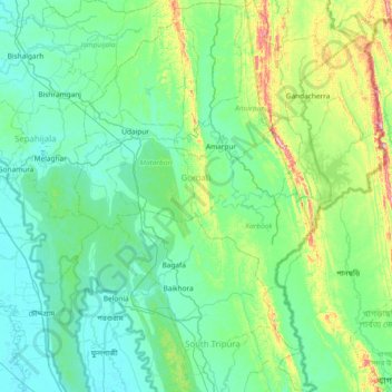
Name: Topografische Karte Gomati, Höhe, Relief.
Ort: Gomati, Tripura, India (23.08611 91.37438 23.76944 91.84517)
Durchschnittliche Höhe: 67 m
Minimale Höhe: 4 m
Maximale Höhe: 385 m
Topographically, the Gomati district is marked by lush green and fertile Gomati valleys. The towering Debtamura hill range which straddles Udaipur and Amarpur subdivisions of the district with its exquisite sculptural works carved on panels of the hills.
Andere topografische Karten
Klicken Sie auf eine Karte, um ihre Topografie, ihre Höhe und ihr Relief anzuzeigen.
Haora River
Haora River, Agartala, West Tripura, Tripura, 799001, India
Durchschnittliche Höhe: 18 m
Kailashahar
India > Tripura > Gournagar > Kailashahar
Kailashahar, Gournagar, Unokoti, Tripura, 799277, India
Durchschnittliche Höhe: 33 m
South Tripura
India > Tripura > South Tripura
South Tripura, Gomati, Tripura, India
Durchschnittliche Höhe: 75 m