
Topografische Karte Karluk
Interaktive Karte
Klicken Sie auf die Karte, um die Höhe anzuzeigen.
Über diese Karte
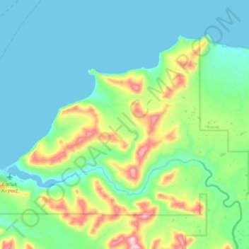
Name: Topografische Karte Karluk, Höhe, Relief.
Ort: Karluk, Kodiak Island, Alaska, 99608, United States (57.54000 -154.52887 57.66375 -154.20966)
Durchschnittliche Höhe: 126 m
Minimale Höhe: 0 m
Maximale Höhe: 622 m
According to the United States Census Bureau, the CDP has a total area of 57.9 square miles (149.9 km2), of which 55.4 square miles (143.6 km2) is land and 2.4 square miles (6.3 km2), or 4.20%, is water. Karluk is 88 miles (142 km) southwest of Kodiak City. The elevation is 137 feet (42 m).
Andere topografische Karten
Klicken Sie auf eine Karte, um ihre Topografie, ihre Höhe und ihr Relief anzuzeigen.
Kodiak
United States > Alaska > Kodiak Island
Kodiak, Kodiak Island, Alaska, United States
Durchschnittliche Höhe: 67 m
Kodiak Station
United States > Alaska > Kodiak Island > Kodiak
Kodiak Station, Kodiak, Kodiak Island, Alaska, 99619, United States
Durchschnittliche Höhe: 105 m
Kodiak
United States > Alaska > Kodiak Island
Kodiak, Kodiak Island, Alaska, United States
Durchschnittliche Höhe: 62 m
Olga Bay
United States > Alaska > Kodiak Island
Olga Bay, Kodiak Island, Alaska, United States
Durchschnittliche Höhe: 81 m
Chiniak
United States > Alaska > Kodiak Island
Chiniak, Kodiak Island, Alaska, United States
Durchschnittliche Höhe: 86 m
Afognak Island
United States > Alaska > Kodiak Island
Afognak Island, Kodiak Island, Alaska, United States
Durchschnittliche Höhe: 71 m