
Topografische Karte Kodiak
Interaktive Karte
Klicken Sie auf die Karte, um die Höhe anzuzeigen.
Über diese Karte
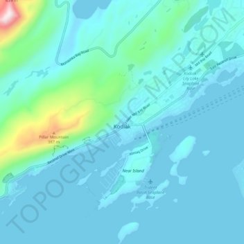
Name: Topografische Karte Kodiak, Höhe, Relief.
Ort: Kodiak, Kodiak Island, Alaska, United States (57.76743 -152.45516 57.81441 -152.35408)
Durchschnittliche Höhe: 62 m
Minimale Höhe: -2 m
Maximale Höhe: 565 m
Andere topografische Karten
Klicken Sie auf eine Karte, um ihre Topografie, ihre Höhe und ihr Relief anzuzeigen.
Kodiak
United States > Alaska > Kodiak Island
Kodiak, Kodiak Island, Alaska, United States
Durchschnittliche Höhe: 67 m
Kodiak Station
United States > Alaska > Kodiak Island > Kodiak
Kodiak Station, Kodiak, Kodiak Island, Alaska, 99619, United States
Durchschnittliche Höhe: 105 m
Olga Bay
United States > Alaska > Kodiak Island
Olga Bay, Kodiak Island, Alaska, United States
Durchschnittliche Höhe: 81 m
Chiniak
United States > Alaska > Kodiak Island
Chiniak, Kodiak Island, Alaska, United States
Durchschnittliche Höhe: 86 m
Karluk
United States > Alaska > Kodiak Island
Karluk, Kodiak Island, Alaska, 99608, United States
Durchschnittliche Höhe: 126 m
Afognak Island
United States > Alaska > Kodiak Island
Afognak Island, Kodiak Island, Alaska, United States
Durchschnittliche Höhe: 71 m