
Topografische Karte Pine Grove
Interaktive Karte
Klicken Sie auf die Karte, um die Höhe anzuzeigen.
Über diese Karte
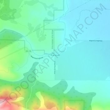
Name: Topografische Karte Pine Grove, Höhe, Relief.
Ort: Pine Grove, Wasco County, Oregon, United States (45.08873 -121.38368 45.12873 -121.34368)
Durchschnittliche Höhe: 713 m
Minimale Höhe: 649 m
Maximale Höhe: 961 m
Andere topografische Karten
Klicken Sie auf eine Karte, um ihre Topografie, ihre Höhe und ihr Relief anzuzeigen.
Dant
United States > Oregon > Wasco County
Dant, Wasco County, Oregon, United States
Durchschnittliche Höhe: 536 m
The Dalles
United States > Oregon > Wasco County
The Dalles, Wasco County, Oregon, United States
Durchschnittliche Höhe: 105 m
Mosier
United States > Oregon > Wasco County
Mosier, Wasco County, Oregon, United States
Durchschnittliche Höhe: 74 m
Tygh Valley
United States > Oregon > Wasco County > Tygh Valley
Tygh Valley, Wasco County, Oregon, United States
Durchschnittliche Höhe: 397 m
Maupin
United States > Oregon > Wasco County
Maupin, Wasco County, Oregon, United States
Durchschnittliche Höhe: 368 m
Shaniko
United States > Oregon > Wasco County > Shaniko
Shaniko, Wasco County, Oregon, United States
Durchschnittliche Höhe: 1.009 m
Frog Lake
United States > Oregon > Wasco County
Frog Lake, Wasco County, Oregon, United States
Durchschnittliche Höhe: 1.266 m