
Topografische Karte Anchorage
Interaktive Karte
Klicken Sie auf die Karte, um die Höhe anzuzeigen.
Über diese Karte
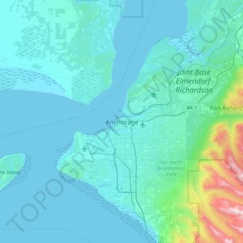
Name: Topografische Karte Anchorage, Höhe, Relief.
Ort: Anchorage, Alaska, 99501, United States (61.05631 -150.05485 61.37631 -149.73485)
Durchschnittliche Höhe: 124 m
Minimale Höhe: 0 m
Maximale Höhe: 1.557 m
Andere topografische Karten
Klicken Sie auf eine Karte, um ihre Topografie, ihre Höhe und ihr Relief anzuzeigen.
Redoubt
United States > Alaska > Anchorage
Redoubt, Anchorage, Alaska, United States
Durchschnittliche Höhe: 49 m
Chugiak
United States > Alaska > Anchorage
Chugiak, Anchorage, Alaska, United States
Durchschnittliche Höhe: 295 m
Chugach Meadows
United States > Alaska > Anchorage > Anchorage
Chugach Meadows, Anchorage, Alaska, United States
Durchschnittliche Höhe: 46 m
Alyeska
United States > Alaska > Anchorage > Girdwood
Alyeska, Girdwood, Anchorage, Alaska, 99523, United States
Durchschnittliche Höhe: 256 m
South Yuyanq’ Ch’ex
United States > Alaska > Anchorage
South Yuyanq’ Ch’ex, Anchorage, Alaska, United States
Durchschnittliche Höhe: 1.071 m
Knik Arm
United States > Alaska > Anchorage
Knik Arm, Anchorage, Alaska, United States
Durchschnittliche Höhe: 72 m
Powder Ridge
United States > Alaska > Anchorage
Powder Ridge, Anchorage, Alaska, United States
Durchschnittliche Höhe: 89 m
Girdwood
United States > Alaska > Anchorage
Girdwood, Anchorage, Alaska, 99587, United States
Durchschnittliche Höhe: 181 m