Geolokalisieren

Topografische Karte Girdwood

Interaktive Karte

Klicken Sie auf die Karte, um die Höhe anzuzeigen.

Über diese Karte

Name: 
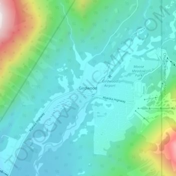
Topografische Karte Girdwood, Höhe, Relief.

Ort: Girdwood, Anchorage, Alaska, 99587, United States (60.94325 -149.15370 60.98325 -149.11370)

Durchschnittliche Höhe: 181 m

Minimale Höhe: 7 m

Maximale Höhe: 978 m

Andere topografische Karten

Klicken Sie auf eine Karte, um ihre Topografie, ihre Höhe und ihr Relief anzuzeigen.

Wilson Village

United States > Alaska > Anchorage > Anchorage

Wilson Village, Anchorage, Alaska, 99598, United States

Durchschnittliche Höhe: 48 m

Redoubt

United States > Alaska > Anchorage

Redoubt, Anchorage, Alaska, United States

Durchschnittliche Höhe: 49 m

Anchorage

United States > Alaska > Anchorage

Anchorage, Alaska, 99501, United States

Durchschnittliche Höhe: 124 m

Chugiak

United States > Alaska > Anchorage

Chugiak, Anchorage, Alaska, United States

Durchschnittliche Höhe: 295 m

Chugach Meadows

United States > Alaska > Anchorage > Anchorage

Chugach Meadows, Anchorage, Alaska, United States

Durchschnittliche Höhe: 46 m

Alyeska

United States > Alaska > Anchorage > Girdwood

Alyeska, Girdwood, Anchorage, Alaska, 99523, United States

Durchschnittliche Höhe: 256 m

South Yuyanq’ Ch’ex

United States > Alaska > Anchorage

South Yuyanq’ Ch’ex, Anchorage, Alaska, United States

Durchschnittliche Höhe: 1.071 m

Knik Arm

United States > Alaska > Anchorage

Knik Arm, Anchorage, Alaska, United States

Durchschnittliche Höhe: 72 m

Powder Ridge

United States > Alaska > Anchorage

Powder Ridge, Anchorage, Alaska, United States

Durchschnittliche Höhe: 89 m