
Topografische Karte Kadmat
Interaktive Karte
Klicken Sie auf die Karte, um die Höhe anzuzeigen.
Über diese Karte
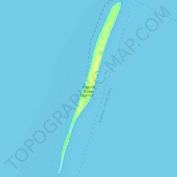
Name: Topografische Karte Kadmat, Höhe, Relief.
Ort: Kadmat, Lakshadweep, India (11.17989 72.75982 11.25910 72.79013)
Durchschnittliche Höhe: 0 m
Minimale Höhe: 0 m
Maximale Höhe: 15 m
Andere topografische Karten
Klicken Sie auf eine Karte, um ihre Topografie, ihre Höhe und ihr Relief anzuzeigen.
Minicoy
Minicoy, Lakshadweep District, Lakshadweep, 682559, India
Durchschnittliche Höhe: 1 m
Kavaratti Island
India > Lakshadweep > Kavaratti > Kavaratti
Kavaratti Island, Kavaratti, Lakshadweep, 262240, India
Durchschnittliche Höhe: 2 m
Kavaratti
India > Lakshadweep > Kavaratti
Kavaratti, Lakshadweep, 262240, India
Durchschnittliche Höhe: 0 m