
Topografische Karte Airway Heights
Interaktive Karte
Klicken Sie auf die Karte, um die Höhe anzuzeigen.
Über diese Karte
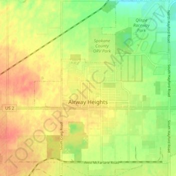
Name: Topografische Karte Airway Heights, Höhe, Relief.
Durchschnittliche Höhe: 724 m
Minimale Höhe: 699 m
Maximale Höhe: 743 m
The community lies in the northeastern corner of the flat Columbia Plateau. While the plateau tends to be flat, the terrain locally is quite rugged as it is part of the Channeled Scablands. The "heights" in the city's name references its location at a higher elevation than the city center of Spokane. Traveling into Airway Heights along U.S. 2, the main road into the city, from Downtown Spokane, one will climb over 500 feet.
Andere topografische Karten
Klicken Sie auf eine Karte, um ihre Topografie, ihre Höhe und ihr Relief anzuzeigen.
Spokane
United States > Washington > Spokane County
Spokane, Spokane County, Washington, United States
Durchschnittliche Höhe: 655 m
Newman Lake
United States > Washington > Spokane County
Newman Lake, Spokane County, Washington, 99025, United States
Durchschnittliche Höhe: 661 m
Hog Lake
United States > Washington > Spokane County
Hog Lake, Spokane County, Washington, United States
Durchschnittliche Höhe: 664 m
Silver Lake
United States > Washington > Spokane County
Silver Lake, Spokane County, Washington, 99022, United States
Durchschnittliche Höhe: 741 m
Mead
United States > Washington > Spokane County
Mead, Spokane County, Washington, 99021, United States
Durchschnittliche Höhe: 585 m
Country Homes
United States > Washington > Spokane County
Country Homes, Spokane County, Washington, 99251, United States
Durchschnittliche Höhe: 599 m
Millwood
United States > Washington > Spokane County
Millwood, Spokane County, Washington, United States
Durchschnittliche Höhe: 600 m
Cheney
United States > Washington > Spokane County
Cheney, Spokane County, Washington, United States
Durchschnittliche Höhe: 728 m
Deer Park
United States > Washington > Spokane County
Deer Park, Spokane County, Washington, 99006, United States
Durchschnittliche Höhe: 658 m
Mount Spokane
United States > Washington > Spokane County
Mount Spokane, Spokane County, Washington, United States
Durchschnittliche Höhe: 1.475 m
Liberty Lake
United States > Washington > Spokane County
Liberty Lake, Spokane County, Washington, 99019, United States
Durchschnittliche Höhe: 644 m
Spokane Valley
United States > Washington > Spokane County
Spokane Valley, Spokane County, Washington, United States
Durchschnittliche Höhe: 673 m
Nine Mile Falls
United States > Washington > Spokane County
Nine Mile Falls, Spokane County, Washington, 99026, United States
Durchschnittliche Höhe: 536 m
Riverside State Park
United States > Washington > Spokane County > Spokane
Riverside State Park, Spokane, Spokane County, Washington, United States
Durchschnittliche Höhe: 645 m
Medical Lake
United States > Washington > Spokane County
Medical Lake, Spokane County, Washington, 99022, United States
Durchschnittliche Höhe: 738 m
Medical Lake
United States > Washington > Spokane County > Medical Lake > Medical Lake
Medical Lake, Spokane County, Washington, 99022, United States
Durchschnittliche Höhe: 747 m
Chattaroy
United States > Washington > Spokane County > Chattaroy
Chattaroy, Spokane County, Washington, 99005, United States
Durchschnittliche Höhe: 559 m