
Topografische Karte Malappuram
Interaktive Karte
Klicken Sie auf die Karte, um die Höhe anzuzeigen.
Über diese Karte
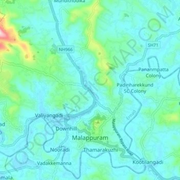
Name: Topografische Karte Malappuram, Höhe, Relief.
Ort: Malappuram, Ernad, Malappuram District, Kerala, India (11.02631 76.03387 11.09641 76.10331)
Durchschnittliche Höhe: 56 m
Minimale Höhe: 9 m
Maximale Höhe: 337 m
Andere topografische Karten
Klicken Sie auf eine Karte, um ihre Topografie, ihre Höhe und ihr Relief anzuzeigen.
Mini Ooty View Point 2
India > Kerala > Ernad > Cheenikkal
Mini Ooty View Point 2, vellur temple road, Cheenikkal, Ernad, Malappuram District, Kerala, 673642, India
Durchschnittliche Höhe: 177 m
Charankavu
Charankavu, Ernad, Malappuram District, Kerala, 676122, India
Durchschnittliche Höhe: 54 m