
Topografische Karte Manjeri
Interaktive Karte
Klicken Sie auf die Karte, um die Höhe anzuzeigen.
Über diese Karte
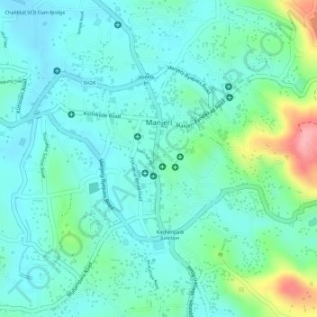
Name: Topografische Karte Manjeri, Höhe, Relief.
Ort: Manjeri, Ernad, Malappuram District, Kerala, 676121, India (11.10677 76.11085 11.12734 76.13068)
Durchschnittliche Höhe: 58 m
Minimale Höhe: 26 m
Maximale Höhe: 158 m
Manjeri is located at 11°07′N 76°07′E / 11.12°N 76.12°E / 11.12; 76.12. It has an average elevation of 38 metres (124 feet) from sea level.
Andere topografische Karten
Klicken Sie auf eine Karte, um ihre Topografie, ihre Höhe und ihr Relief anzuzeigen.
Mini Ooty View Point 2
India > Kerala > Ernad > Cheenikkal
Mini Ooty View Point 2, vellur temple road, Cheenikkal, Ernad, Malappuram District, Kerala, 673642, India
Durchschnittliche Höhe: 177 m
Charankavu
Charankavu, Ernad, Malappuram District, Kerala, 676122, India
Durchschnittliche Höhe: 54 m
Malappuram
Malappuram, Ernad, Malappuram District, Kerala, India
Durchschnittliche Höhe: 56 m