
Spenden
Rüsten Sie sich für Ihr nächstes Abenteuer:
Als Amazon-Partner verdient diese Website an qualifizierten Käufen, ohne dass Ihnen zusätzliche Kosten entstehen.
Topografische Karte Maloja
Klicken Sie auf die Karte, um die Höhe anzuzeigen.
Spenden
Rüsten Sie sich für Ihr nächstes Abenteuer:
Als Amazon-Partner verdient diese Website an qualifizierten Käufen, ohne dass Ihnen zusätzliche Kosten entstehen.
Über diese Karte
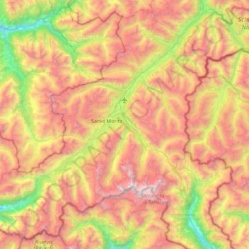
Name: Topografische Karte Maloja, Höhe, Relief.
Ort: Maloja, Grisons, Switzerland (46.28599 9.45628 46.69625 10.10235)
Durchschnittliche Höhe: 2.313 m
Minimale Höhe: 890 m
Maximale Höhe: 3.952 m
Spenden
Rüsten Sie sich für Ihr nächstes Abenteuer:
Als Amazon-Partner verdient diese Website an qualifizierten Käufen, ohne dass Ihnen zusätzliche Kosten entstehen.
Andere topografische Karten
Klicken Sie auf eine Karte, um ihre Topografie, ihre Höhe und ihr Relief anzuzeigen.
Albulapass
Switzerland > Grisons > Maloja > La Punt Chamues-ch
The Albula Pass is an important axis from central Graubünden to Engadin. It is traversed by a paved road from Thusis to La Punt, via Bergün. It is also traversed by the Albula Railway, although at a lower elevation through the Albula Tunnel (1,820 m), from Thusis to Bever, also via Bergün.
Durchschnittliche Höhe: 2.560 m
Spenden
Rüsten Sie sich für Ihr nächstes Abenteuer:
Als Amazon-Partner verdient diese Website an qualifizierten Käufen, ohne dass Ihnen zusätzliche Kosten entstehen.
Berninapass
Switzerland > Grisons > Maloja > Pontresina
The building of the road began in 1842. Head of engineers was Rudolf Albertini (1821–1896) from Zuoz. The work was finished in 1865 and a hospice at an elevation of 2,307 metres (7,569 ft) was also opened. Since this time the road has been widened several times. Since 1965 it has been open all year round,…
Durchschnittliche Höhe: 2.351 m
Spenden
Rüsten Sie sich für Ihr nächstes Abenteuer:
Als Amazon-Partner verdient diese Website an qualifizierten Käufen, ohne dass Ihnen zusätzliche Kosten entstehen.
Spenden
Rüsten Sie sich für Ihr nächstes Abenteuer:
Als Amazon-Partner verdient diese Website an qualifizierten Käufen, ohne dass Ihnen zusätzliche Kosten entstehen.
Lägh dal Lunghin
Switzerland > Grisons > Maloja
Lägh dal Lunghin (German: Lunghinsee) is a lake at an elevation of 2484 m, below the peak of Piz Lunghin, in the Graubünden, Switzerland. It is considered the source of the Inn River.
Durchschnittliche Höhe: 2.456 m
Spenden
Rüsten Sie sich für Ihr nächstes Abenteuer:
Als Amazon-Partner verdient diese Website an qualifizierten Käufen, ohne dass Ihnen zusätzliche Kosten entstehen.
Casaccia
Switzerland > Grisons > Maloja
Casaccia is a village located in the Val Bregaglia, in the Swiss canton of Graubünden. It lies at an altitude of 1,458 metres above sea level, at the southern foot of Piz Lunghin. The village belongs to the municipality of Bregaglia.
Durchschnittliche Höhe: 1.929 m
Sankt Moritz
Switzerland > Grisons > Maloja > Sankt Moritz > Sankt Moritz
Durchschnittliche Höhe: 2.185 m
Spenden
Rüsten Sie sich für Ihr nächstes Abenteuer:
Als Amazon-Partner verdient diese Website an qualifizierten Käufen, ohne dass Ihnen zusätzliche Kosten entstehen.