
Spenden
Rüsten Sie sich für Ihr nächstes Abenteuer:
Als Amazon-Partner verdient diese Website an qualifizierten Käufen, ohne dass Ihnen zusätzliche Kosten entstehen.
Topografische Karte Soglio
Klicken Sie auf die Karte, um die Höhe anzuzeigen.
Spenden
Rüsten Sie sich für Ihr nächstes Abenteuer:
Als Amazon-Partner verdient diese Website an qualifizierten Käufen, ohne dass Ihnen zusätzliche Kosten entstehen.
Über diese Karte
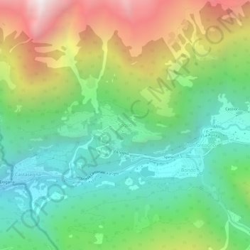
Name: Topografische Karte Soglio, Höhe, Relief.
Ort: Soglio, Bregaglia, Maloja, Grisons, 7610, Switzerland (46.32207 9.51988 46.36207 9.55988)
Durchschnittliche Höhe: 1.357 m
Minimale Höhe: 659 m
Maximale Höhe: 2.612 m
Spenden
Rüsten Sie sich für Ihr nächstes Abenteuer:
Als Amazon-Partner verdient diese Website an qualifizierten Käufen, ohne dass Ihnen zusätzliche Kosten entstehen.
Andere topografische Karten
Klicken Sie auf eine Karte, um ihre Topografie, ihre Höhe und ihr Relief anzuzeigen.
Sankt Moritz
Switzerland > Grisons > Maloja
St. Moritz (also German: Sankt Moritz, Romansh: San Murezzan (help·info), Italian: San Maurizio, French: Saint-Moritz) is a high Alpine resort town in the Engadine in Switzerland, at an elevation of about 1,800 metres (5,910 ft) above sea level. It is Upper Engadine's major town and a municipality in the…
Durchschnittliche Höhe: 2.173 m
Sankt Moritz
Switzerland > Grisons > Maloja
St. Moritz (/ˌsæn məˈrɪts/ SAN mə-RITS, US also /ˌseɪnt -/ SAYNT -, UK also /sənt ˈmɒrɪts/ sənt MORR-its; German, in full: Sankt Moritz [zaŋkt moˈrɪts, ˈmoːrɪts] locally [saŋkt]; Romansh: San Murezzan [sam muˈʁetsən] ; Italian: San Maurizio; French: Saint-Moritz) is a high Alpine…
Durchschnittliche Höhe: 2.173 m
Pontresina
Switzerland > Grisons > Maloja
Before 2017, the municipality was located in the Oberengadin sub-district of the Maloja district, after 2017 it was part of the Maloja Region. It sits in Val Bernina, which is the highest altitude valley that branches off the Upper Engadin Valley. The municipality includes the highest mountain of the canton,…
Durchschnittliche Höhe: 2.580 m
Spenden
Rüsten Sie sich für Ihr nächstes Abenteuer:
Als Amazon-Partner verdient diese Website an qualifizierten Käufen, ohne dass Ihnen zusätzliche Kosten entstehen.
Pontresina
Switzerland > Grisons > Maloja
Before 2017, the municipality was located in the Oberengadin sub-district of the Maloja district, after 2017 it was part of the Maloja Region. It sits in Val Bernina, which is the highest altitude valley that branches off the Upper Engadin Valley. The municipality includes the highest mountain of the canton,…
Durchschnittliche Höhe: 2.580 m
Sankt Moritz
Switzerland > Grisons > Maloja
St. Moritz (/ˌsæn məˈrɪts/ SAN mə-RITS, US also /ˌseɪnt -/ SAYNT -, UK also /sənt ˈmɒrɪts/ sənt MORR-its; German, in full: Sankt Moritz [zaŋkt moˈrɪts, ˈmoːrɪts] locally [saŋkt]; Romansh: San Murezzan [sam muˈʁetsən] ; Italian: San Maurizio; French: Saint-Moritz) is a high Alpine…
Durchschnittliche Höhe: 2.173 m
Pontresina
Switzerland > Grisons > Maloja
Before 2017, the municipality was located in the Oberengadin sub-district of the Maloja district, after 2017 it was part of the Maloja Region. It sits in Val Bernina, which is the highest altitude valley that branches off the Upper Engadin Valley. The municipality includes the highest mountain of the canton,…
Durchschnittliche Höhe: 2.580 m
Spenden
Rüsten Sie sich für Ihr nächstes Abenteuer:
Als Amazon-Partner verdient diese Website an qualifizierten Käufen, ohne dass Ihnen zusätzliche Kosten entstehen.
Spenden
Rüsten Sie sich für Ihr nächstes Abenteuer:
Als Amazon-Partner verdient diese Website an qualifizierten Käufen, ohne dass Ihnen zusätzliche Kosten entstehen.
Lägh dal Lunghin
Switzerland > Grisons > Maloja
Lägh dal Lunghin (German: Lunghinsee) is a lake at an elevation of 2484 m, below the peak of Piz Lunghin, in the Graubünden, Switzerland. It is considered the source of the Inn River.
Durchschnittliche Höhe: 2.456 m