
Topografische Karte Butajira
Interaktive Karte
Klicken Sie auf die Karte, um die Höhe anzuzeigen.
Über diese Karte
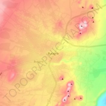
Name: Topografische Karte Butajira, Höhe, Relief.
Durchschnittliche Höhe: 2.078 m
Minimale Höhe: 1.861 m
Maximale Höhe: 2.220 m
Andere topografische Karten
Klicken Sie auf eine Karte, um ihre Topografie, ihre Höhe und ihr Relief anzuzeigen.
Belta
Ethiopia > Southern Nations, Nationalities, and Peoples
Belta, Gamo Gofa, Southern Nations, Nationalities, and Peoples, Ethiopia
Durchschnittliche Höhe: 2.613 m
Nech Sar National Park
Ethiopia > Southern Nations, Nationalities, and Peoples > Arba Minch
Nech Sar National Park, Arba Minch, Gamo Gofa, Southern Nations, Nationalities, and Peoples, Ethiopia
Durchschnittliche Höhe: 1.215 m
Kore
Ethiopia > Southern Nations, Nationalities, and Peoples > Nili
Kore, Nili, South Omo, Southern Nations, Nationalities, and Peoples, Ethiopia
Durchschnittliche Höhe: 544 m
Gamo Gofa
Ethiopia > Southern Nations, Nationalities, and Peoples
Gamo Gofa, Southern Nations, Nationalities, and Peoples, Ethiopia
Durchschnittliche Höhe: 1.502 m
Southern Nations, Nationalities, and Peoples
Ethiopia > Southern Nations, Nationalities, and Peoples
Southern Nations, Nationalities, and Peoples, Ethiopia
Durchschnittliche Höhe: 1.382 m