
Topografische Karte Haliburton County
Klicken Sie auf die Karte, um die Höhe anzuzeigen.
Über diese Karte
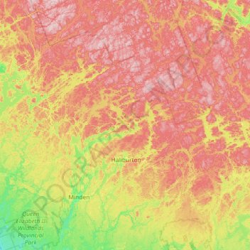
Name: Topografische Karte Haliburton County, Höhe, Relief.
Ort: Haliburton County, Central Ontario, Ontario, Canada (44.75378 -79.00099 45.56146 -77.96119)
Durchschnittliche Höhe: 392 m
Minimale Höhe: 251 m
Maximale Höhe: 559 m
Andere topografische Karten
Klicken Sie auf eine Karte, um ihre Topografie, ihre Höhe und ihr Relief anzuzeigen.
Toronto
Despite its deep ravines, Toronto is not remarkably hilly, but its elevation does increase steadily away from the lake. Elevation differences range from 76.5 metres (251 ft) above sea level at the Lake Ontario shore to 209 m (686 ft) ASL near the York University grounds in the city's north end at the…
Durchschnittliche Höhe: 113 m
Guelph
This region of Ontario has cold winters and warm, humid summers, falling into the Köppen climate classification Dfb zone, with moderately high rainfall and snowfall. It is generally a couple of degrees cooler than lower elevation regions on the Great Lakes shorelines, especially so in winter, the exception…
Durchschnittliche Höhe: 344 m
London
Canada > Ontario > London > London
London has a humid continental climate (Köppen Dfb), though due to its downwind location relative to Lake Huron and elevation changes across the city, it is virtually on the Dfa/Dfb (hot summer) boundary favouring the former climate zone to the southwest of the confluence of the South and North Thames Rivers,…
Durchschnittliche Höhe: 268 m
Silent Lake Provincial Park
Canada > Ontario > Haliburton County > Highlands East
Durchschnittliche Höhe: 371 m
Batchawana Bay
Canada > Ontario > Algoma District > Unorganized North Algoma
Durchschnittliche Höhe: 198 m
Peterborough
Canada > Ontario > Peterborough
Peterborough's topography is largely defined by land formations created by the receding Wisconsian glaciers 10,000–15,000 years ago. The South End and Downtown portions of the City sit on what was the bottom of the glacial Lake Peterborough—part of a glacial spillway created when glacial meltwaters from…
Durchschnittliche Höhe: 235 m
Sioux Narrows
Canada > Ontario > Kenora District > Sioux Narrows-Nestor Falls Township
Durchschnittliche Höhe: 329 m
Little Crosby Lake
Canada > Ontario > Leeds and Grenville Counties > Rideau Lakes
Durchschnittliche Höhe: 166 m
La Cloche Provincial Park
Canada > Ontario > Sudbury District > Sables-Spanish Rivers Township
Durchschnittliche Höhe: 224 m
Lyndhurst
Canada > Ontario > Leeds and Grenville Counties > Leeds and the Thousand Islands
Durchschnittliche Höhe: 98 m
Burditt Lake
Canada > Ontario > Kenora District > Unorganized Kenora District
Durchschnittliche Höhe: 367 m
Tomlinson Lake
Canada > Ontario > Thunder Bay District > Unorganized Thunder Bay District
Durchschnittliche Höhe: 489 m
London
London has a humid continental climate (Köppen Dfb), though due to its downwind location relative to Lake Huron and elevation changes across the city, it is virtually on the Dfa/Dfb (hot summer) boundary favouring the former climate zone to the southwest of the confluence of the South and North Thames Rivers,…
Durchschnittliche Höhe: 269 m
Whitefish Lake
Canada > Ontario > Thunder Bay District > Unorganized Thunder Bay District
Durchschnittliche Höhe: 472 m
Jack Lake
Canada > Ontario > Cochrane District > Unorganized North Cochrane
Durchschnittliche Höhe: 274 m
Tobermory
Canada > Ontario > Northern Bruce Peninsula > Tobermory
The deep waters at the mouth of Georgian Bay are home to Fathom Five, Canada's first National Marine Conservation Area. The park preserves a rich cultural legacy that includes 22 shipwrecks and several historic lighthouses. Fathom Five's freshwater ecosystem contains some of the most pristine waters of the…
Durchschnittliche Höhe: 182 m
Frontenac Provincial Park
Canada > Ontario > South Frontenac
Frontenac Provincial Park is located near the town of Sydenham, north of the city of Kingston, Ontario, Canada. The Government of Ontario has classified Frontenac Provincial Park as a natural environment park. The park lies on the Frontenac Axis, a topographic extension of the Canadian Shield, which connects…
Durchschnittliche Höhe: 151 m
Lake Bernard
Canada > Ontario > Parry Sound District > Strong Township > Sundridge
Durchschnittliche Höhe: 347 m