Geolokalisieren
👉 Easily get elevation data in JSON, GeoTIFF and KML formats using Elevation API
Vielen Dank für die Unterstützung dieser Website ❤️
Spenden

Rüsten Sie sich für Ihr nächstes Abenteuer:

Als Amazon-Partner verdient diese Website an qualifizierten Käufen, ohne dass Ihnen zusätzliche Kosten entstehen.

Topografische Karte Bigwin Island

Klicken Sie auf die Karte, um die Höhe anzuzeigen.

👉 Easily get elevation data in JSON, GeoTIFF and KML formats using Elevation API
Vielen Dank für die Unterstützung dieser Website ❤️
Spenden

Über diese Karte

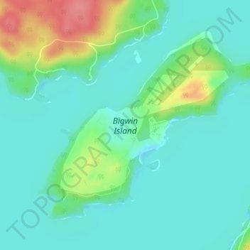
Name: Topografische Karte Bigwin Island, Höhe, Relief.

Ort: Bigwin Island, Lake of Bays Township, District Municipality of Muskoka, Muskoka District, Central Ontario, Ontario, Canada (45.23217 -79.04388 45.25258 -79.00699)

Durchschnittliche Höhe: 328 m

Minimale Höhe: 307 m

Maximale Höhe: 389 m

Andere topografische Karten

Klicken Sie auf eine Karte, um ihre Topografie, ihre Höhe und ihr Relief anzuzeigen.

Toronto

Canada > Ontario > Toronto

Despite its deep ravines, Toronto is not remarkably hilly, but its elevation does increase steadily away from the lake. Elevation differences range from 76.5 metres (251 ft) above sea level at the Lake Ontario shore to 209 m (686 ft) ASL near the York University grounds in the city's north end at the…

Durchschnittliche Höhe: 113 m

Ottawa

Canada > Ontario

Ottawa, the capital city of Canada, is situated on the south bank of the Ottawa River at the confluence with the Rideau River. The city's topography is characterized by gently rolling terrain with elevations ranging from approximately 44 meters (144 feet) above sea level at the Ottawa River to its highest…

Durchschnittliche Höhe: 105 m

Toronto

Canada > Ontario

Despite its deep ravines, Toronto is not remarkably hilly, but its elevation does increase steadily away from the lake. Elevation differences range from 76.5 metres (251 ft) above sea level at the Lake Ontario shore to 209 m (686 ft) above sea level near the York University grounds in the city's north end at…

Durchschnittliche Höhe: 139 m

Kitchener

Canada > Ontario > Region of Waterloo

Kitchener is located in Southwestern Ontario, in the Saint Lawrence Lowlands. This geological and climatic region has wet-climate soils and deciduous forests. Situated in the Grand River Valley, the area is generally above 300 m (1,000 ft) in elevation.

Durchschnittliche Höhe: 336 m

Vielen Dank für die Unterstützung dieser Website ❤️
Spenden

Rüsten Sie sich für Ihr nächstes Abenteuer:

Als Amazon-Partner verdient diese Website an qualifizierten Käufen, ohne dass Ihnen zusätzliche Kosten entstehen.

London

Canada > Ontario > London > London

London has a humid continental climate (Köppen Dfb), though due to its downwind location relative to Lake Huron and elevation changes across the city, it is virtually on the Dfa/Dfb (hot summer) boundary favouring the former climate zone to the southwest of the confluence of the South and North Thames Rivers,…

Durchschnittliche Höhe: 268 m

Guelph

Canada > Ontario > Guelph

This region of Ontario has cold winters and warm, humid summers, falling into the Köppen climate classification Dfb zone, with moderately high rainfall and snowfall. It is generally a couple of degrees cooler than lower elevation regions on the Great Lakes shorelines, especially so in winter, the exception…

Durchschnittliche Höhe: 344 m

Hamilton

Canada > Ontario > Hamilton

Durchschnittliche Höhe: 181 m

Mississauga

Canada > Ontario > Peel Region

The shoreline of former Glacial Lake Iroquois roughly follows the Dundas Street alignment, although it is not noticeable in some places but is more prominent in others, such as the site of the former brickyard (Shoreline Dr. near Mavis Rd.), the ancient shoreline promenteau affords a clear view of downtown…

Durchschnittliche Höhe: 151 m

Vielen Dank für die Unterstützung dieser Website ❤️
Spenden

Rüsten Sie sich für Ihr nächstes Abenteuer:

Als Amazon-Partner verdient diese Website an qualifizierten Käufen, ohne dass Ihnen zusätzliche Kosten entstehen.

Barrie

Canada > Ontario > Barrie

Durchschnittliche Höhe: 248 m

Whitby

Canada > Ontario > Durham Region

Durchschnittliche Höhe: 155 m

Georgian Bluffs

Canada > Ontario > Grey County

Durchschnittliche Höhe: 228 m

Niagara Falls

Canada > Ontario > Niagara Region

Durchschnittliche Höhe: 179 m

Vielen Dank für die Unterstützung dieser Website ❤️
Spenden

Toronto

Canada > Ontario

Despite its deep ravines, Toronto is not remarkably hilly, but its elevation does increase steadily away from the lake. Elevation differences range from 76.5 metres (251 ft) above sea level at the Lake Ontario shore to 209 m (686 ft) ASL near the York University grounds in the city's north end at the…

Durchschnittliche Höhe: 139 m

Waterloo

Canada > Ontario > Region of Waterloo

Durchschnittliche Höhe: 341 m

Lake Scugog

Canada > Ontario > Durham Region > Kawartha Lakes

The stagnant waters of the lake caused a wave of deadly fevers in the surrounding farms, and the new lake limits quickly became very unpopular with the local residents. On one day in the summer of 1838, settlers from the countryside surrounding the lake rose up and using axes, flintlocks and pitchforks, tore…

Durchschnittliche Höhe: 269 m

Port Hope

Canada > Ontario > Northumberland County

Durchschnittliche Höhe: 161 m

Lake Ontario

Canada > Ontario

Lake Ontario is the easternmost of the Great Lakes and the smallest in surface area (7,340 sq mi, 18,960 km2), although it exceeds Lake Erie in volume (393 cu mi, 1,639 km3). It is the 13th largest lake in the world. When its islands are included, the lake's shoreline is 712 miles (1,146 km) long. As the last…

Durchschnittliche Höhe: 214 m

Orléans

Canada > Ontario > Ottawa > Cumberland

Durchschnittliche Höhe: 66 m

Oro-Medonte

Canada > Ontario > Simcoe County

Durchschnittliche Höhe: 246 m

Sturgeon Lake

Canada > Ontario > Kawartha Lakes

Durchschnittliche Höhe: 266 m

Brantford

Canada > Ontario > Brantford

Durchschnittliche Höhe: 238 m

Cambridge

Canada > Ontario > Cambridge

Durchschnittliche Höhe: 295 m

Greater Sudbury

Canada > Ontario > Sudbury District

Durchschnittliche Höhe: 305 m

Renfrew County

Canada > Ontario

Durchschnittliche Höhe: 283 m

Vielen Dank für die Unterstützung dieser Website ❤️
Spenden

Rüsten Sie sich für Ihr nächstes Abenteuer:

Als Amazon-Partner verdient diese Website an qualifizierten Käufen, ohne dass Ihnen zusätzliche Kosten entstehen.

Sudbury

Canada > Ontario > Greater Sudbury

Durchschnittliche Höhe: 272 m

Ottawa

Canada > Ontario > Ottawa > Ottawa

Durchschnittliche Höhe: 99 m

Southwestern Ontario

Canada > Ontario

Durchschnittliche Höhe: 235 m

Chemong Lake

Canada > Ontario > Peterborough County > Selwyn > Bridgenorth

Durchschnittliche Höhe: 256 m

Vielen Dank für die Unterstützung dieser Website ❤️
Spenden

Rüsten Sie sich für Ihr nächstes Abenteuer:

Als Amazon-Partner verdient diese Website an qualifizierten Käufen, ohne dass Ihnen zusätzliche Kosten entstehen.

Thunder Bay

Canada > Ontario > Thunder Bay District

Durchschnittliche Höhe: 240 m

Chatham-Kent

Canada > Ontario

Durchschnittliche Höhe: 183 m

Kawartha Lakes

Canada > Ontario > Kawartha Lakes

Durchschnittliche Höhe: 269 m

Bonnechere River

Canada > Ontario

Durchschnittliche Höhe: 272 m

Vielen Dank für die Unterstützung dieser Website ❤️
Spenden

Rüsten Sie sich für Ihr nächstes Abenteuer:

Als Amazon-Partner verdient diese Website an qualifizierten Käufen, ohne dass Ihnen zusätzliche Kosten entstehen.

Norfolk County

Canada > Ontario

Durchschnittliche Höhe: 216 m

Smiths Falls

Canada > Ontario

Durchschnittliche Höhe: 123 m

St. Catharines

Canada > Ontario > Niagara Region

The most defining transportation icon of St. Catharines is the Welland Canal, a ship canal that runs 43.4 kilometres (27.0 mi), passing through the city. Four of its locks are within city boundaries. The canal allows shipping vessels to traverse the 99.5-metre (326.5 ft) drop in altitude from Lake Erie to Lake…

Durchschnittliche Höhe: 103 m

Parry Sound

Canada > Ontario

Durchschnittliche Höhe: 235 m

Algonquin Provincial Park

Canada > Ontario

Durchschnittliche Höhe: 386 m

Innisfil

Canada > Ontario > Simcoe County

Durchschnittliche Höhe: 243 m

Eastern Ontario

Canada > Ontario

Along the extreme western edge of Eastern Ontario is a continuation of the Laurentian Highlands, known as the Opeongo Hills, and they contain some of the highest elevations in Southern Ontario. They stretch into the northern portions of Central Ontario, near Algonquin Provincial Park.

Durchschnittliche Höhe: 243 m

Gloucester Pool

Canada > Ontario > Georgian Bay Township

Durchschnittliche Höhe: 186 m

Esnagi Lake

Canada > Ontario > Unorganized North Algoma

Durchschnittliche Höhe: 391 m

Whitchurch-Stouffville

Canada > Ontario > York Region

Durchschnittliche Höhe: 250 m

Burlington

Canada > Ontario > Halton Region

Durchschnittliche Höhe: 141 m

Vielen Dank für die Unterstützung dieser Website ❤️
Spenden

Pembroke

Canada > Ontario

Durchschnittliche Höhe: 128 m

Osgoode

Canada > Ontario > Ottawa

Durchschnittliche Höhe: 91 m

Clarington

Canada > Ontario > Durham Region

Durchschnittliche Höhe: 189 m

Bronte Creek

Canada > Ontario > Halton Region > Burlington

Durchschnittliche Höhe: 218 m

Vielen Dank für die Unterstützung dieser Website ❤️
Spenden

Rüsten Sie sich für Ihr nächstes Abenteuer:

Als Amazon-Partner verdient diese Website an qualifizierten Käufen, ohne dass Ihnen zusätzliche Kosten entstehen.

Ottawa River

Canada > Ontario > Ottawa > Pontiac

Durchschnittliche Höhe: 318 m

Stittsville

Canada > Ontario > Ottawa

Durchschnittliche Höhe: 111 m

Ottawa

Canada > Ontario > Ottawa

Durchschnittliche Höhe: 93 m

Balsam Lake

Canada > Ontario > Kawartha Lakes

Durchschnittliche Höhe: 257 m

Mount Nemo

Canada > Ontario > Halton Region > Burlington

Durchschnittliche Höhe: 248 m

Algonquin Highlands

Canada > Ontario > Haliburton County

Durchschnittliche Höhe: 399 m

Vielen Dank für die Unterstützung dieser Website ❤️
Spenden

Woodstock

Canada > Ontario > Woodstock

Durchschnittliche Höhe: 306 m

Delaware

Canada > Ontario > Middlesex County > Middlesex Centre

Durchschnittliche Höhe: 224 m

Crow Lake

Canada > Ontario > Kenora District

Durchschnittliche Höhe: 350 m

French River

Canada > Ontario > Parry Sound District

Durchschnittliche Höhe: 207 m

Peterborough

Canada > Ontario > Peterborough

Peterborough's topography is largely defined by land formations created by the receding Wisconsian glaciers 10,000–15,000 years ago. The South End and Downtown portions of the City sit on what was the bottom of the glacial Lake Peterborough—part of a glacial spillway created when glacial meltwaters from…

Durchschnittliche Höhe: 235 m

Frontenac County

Canada > Ontario

Durchschnittliche Höhe: 169 m

Hastings County

Canada > Ontario

Durchschnittliche Höhe: 288 m

Lake Nipissing

Canada > Ontario > Nipissing District

Lake Nipissing (/ˈnɪpəsɪŋ/; French: lac Nipissing, Ojibwe: Gichi-nibiinsing-zaaga’igan) is a lake in the Canadian province of Ontario. It has a surface area of 873.3 km2 (337.2 sq mi), a mean elevation of 196 m (643 ft) above sea level, and is located between the Ottawa River and Georgian Bay. Lake…

Durchschnittliche Höhe: 272 m

Thunder Bay District

Canada > Ontario

Durchschnittliche Höhe: 321 m

Huron County

Canada > Ontario

Durchschnittliche Höhe: 274 m

Niagara Region

Canada > Ontario

Durchschnittliche Höhe: 148 m

St. Johns

Canada > Ontario

Durchschnittliche Höhe: 205 m

Vielen Dank für die Unterstützung dieser Website ❤️
Spenden

Eels Lake

Canada > Ontario > Peterborough County > North Kawartha

Durchschnittliche Höhe: 361 m

Drag lake

Canada > Ontario > Haliburton County > Dysart et al > Haliburton

Durchschnittliche Höhe: 394 m

Markham

Canada > Ontario > York Region

Markham's average altitude is at 200 m (660 ft) and in general consists of gently rolling hills. The city is intersected by two rivers; the Don River and Rouge River, as well as their tributaries. To the north is the Oak Ridges Moraine, which further elevates the elevation towards the north.

Durchschnittliche Höhe: 216 m

Richmond Hill

Canada > Ontario > York Region

The village of Richmond Hill was incorporated by a bylaw of the York County Council on June 18, 1872, coming into effect January 1, 1873. In September 1956, the Ontario Municipal Board approved its elevation to Town status, effective January 1, 1957.

Durchschnittliche Höhe: 256 m

Vielen Dank für die Unterstützung dieser Website ❤️
Spenden

Rüsten Sie sich für Ihr nächstes Abenteuer:

Als Amazon-Partner verdient diese Website an qualifizierten Käufen, ohne dass Ihnen zusätzliche Kosten entstehen.

Woodstock

Canada > Ontario > Oxford County

Durchschnittliche Höhe: 308 m

Bancroft

Canada > Ontario > Hastings County

Durchschnittliche Höhe: 370 m

Collingwood

Canada > Ontario > Simcoe County

Durchschnittliche Höhe: 190 m

Grand River

Canada > Ontario

Durchschnittliche Höhe: 300 m

Vielen Dank für die Unterstützung dieser Website ❤️
Spenden

Rüsten Sie sich für Ihr nächstes Abenteuer:

Als Amazon-Partner verdient diese Website an qualifizierten Käufen, ohne dass Ihnen zusätzliche Kosten entstehen.

Barrhaven West

Canada > Ontario > Ottawa

Durchschnittliche Höhe: 99 m

Orillia

Canada > Ontario

Durchschnittliche Höhe: 234 m

Niagara Escarpment

Canada > Ontario

Durchschnittliche Höhe: 299 m

Salmon Lake

Canada > Ontario > Parry Sound District > Seguin Township

Durchschnittliche Höhe: 220 m

Vielen Dank für die Unterstützung dieser Website ❤️
Spenden

Rüsten Sie sich für Ihr nächstes Abenteuer:

Als Amazon-Partner verdient diese Website an qualifizierten Käufen, ohne dass Ihnen zusätzliche Kosten entstehen.

St. Jacobs

Canada > Ontario > Region of Waterloo > Woolwich

Durchschnittliche Höhe: 341 m

St. Thomas

Canada > Ontario

Durchschnittliche Höhe: 234 m

Haliburton

Canada > Ontario

Durchschnittliche Höhe: 358 m

Vielen Dank für die Unterstützung dieser Website ❤️
Spenden

Rüsten Sie sich für Ihr nächstes Abenteuer:

Als Amazon-Partner verdient diese Website an qualifizierten Käufen, ohne dass Ihnen zusätzliche Kosten entstehen.

Sault Ste. Marie

Canada > Ontario > Algoma District

Durchschnittliche Höhe: 249 m

Simcoe County

Canada > Ontario

The road network in Simcoe County is based on a grid pattern, with most roads running north–south or east–west. The topography of the land has permitted roads to be set in predominantly straight lines.

Durchschnittliche Höhe: 265 m

Kearney

Canada > Ontario > Parry Sound District

Durchschnittliche Höhe: 388 m

Belleville

Canada > Ontario > Belleville

Durchschnittliche Höhe: 107 m

Vielen Dank für die Unterstützung dieser Website ❤️
Spenden

Rüsten Sie sich für Ihr nächstes Abenteuer:

Als Amazon-Partner verdient diese Website an qualifizierten Käufen, ohne dass Ihnen zusätzliche Kosten entstehen.

Stratford

Canada > Ontario > Stratford

Durchschnittliche Höhe: 356 m

Milton

Canada > Ontario > Halton Region

Durchschnittliche Höhe: 237 m

York Region

Canada > Ontario

Durchschnittliche Höhe: 243 m

Lindsay

Canada > Ontario > Kawartha Lakes

Durchschnittliche Höhe: 268 m

Brampton

Canada > Ontario > Peel Region

Durchschnittliche Höhe: 223 m

Essex

Canada > Ontario

Durchschnittliche Höhe: 193 m

Vielen Dank für die Unterstützung dieser Website ❤️
Spenden

Rüsten Sie sich für Ihr nächstes Abenteuer:

Als Amazon-Partner verdient diese Website an qualifizierten Käufen, ohne dass Ihnen zusätzliche Kosten entstehen.

Wasaga Beach

Canada > Ontario > Simcoe County

The Town of Wasaga Beach covers an area of 61.13 square kilometres (23.60 sq mi) comprised predominantly of sand and loamy sand that exhibit excessive to good drainage and irregular to moderately sloping topography. The poor soil quality makes it difficult to sustain lush lawns in the town. The Canada Land…

Durchschnittliche Höhe: 190 m

Bradford West Gwillimbury

Canada > Ontario > Simcoe County

Durchschnittliche Höhe: 249 m

Hanover

Canada > Ontario > Grey County

Durchschnittliche Höhe: 278 m

Port Perry

Canada > Ontario > Durham Region > Scugog

Durchschnittliche Höhe: 263 m

Vielen Dank für die Unterstützung dieser Website ❤️
Spenden

Rüsten Sie sich für Ihr nächstes Abenteuer:

Als Amazon-Partner verdient diese Website an qualifizierten Käufen, ohne dass Ihnen zusätzliche Kosten entstehen.

Rüsten Sie sich für Ihr nächstes Abenteuer:

🗺️Topographische Karten - Detaillierte Karten für Outdoor und Navigation
💾SD-Karte 128GB - Viel Speicherplatz für Fotos und topografische Daten
🚲Radwanderkarte Luxemburg - Die besten Radwege durch das Land der Roten Erde
🥪Edelstahl Brotdose - Nachhaltige und robuste Aufbewahrung für die Brotzeit
📱Wasserdichte Handyhülle - Schützt das Smartphone vor Regen und Stürzen

Als Amazon-Partner verdient diese Website an qualifizierten Käufen, ohne dass Ihnen zusätzliche Kosten entstehen.