
Topografische Karte Province of Atalaya
Interaktive Karte
Klicken Sie auf die Karte, um die Höhe anzuzeigen.
Über diese Karte
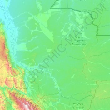
Name: Topografische Karte Province of Atalaya, Höhe, Relief.
Ort: Province of Atalaya, Ucayali, Peru (-11.44834 -74.57300 -9.41140 -72.12017)
Durchschnittliche Höhe: 440 m
Minimale Höhe: 153 m
Maximale Höhe: 3.652 m
Andere topografische Karten
Klicken Sie auf eine Karte, um ihre Topografie, ihre Höhe und ihr Relief anzuzeigen.
Yarinacocha
Yarinacocha, Province of Coronel Portillo, Ucayali, Peru
Durchschnittliche Höhe: 144 m
Province of Coronel Portillo
Province of Coronel Portillo, Ucayali, Peru
Durchschnittliche Höhe: 253 m
Río Ucayali
Río Ucayali, Iparía, Province of Coronel Portillo, Ucayali, Peru
Durchschnittliche Höhe: 161 m