
Topografische Karte Stormont, Dundas and Glengarry Counties
Interaktive Karte
Klicken Sie auf die Karte, um die Höhe anzuzeigen.
Über diese Karte
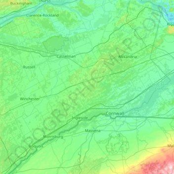
Name: Topografische Karte Stormont, Dundas and Glengarry Counties, Höhe, Relief.
Durchschnittliche Höhe: 86 m
Minimale Höhe: 20 m
Maximale Höhe: 595 m
Andere topografische Karten
Klicken Sie auf eine Karte, um ihre Topografie, ihre Höhe und ihr Relief anzuzeigen.
Wyoming
Kanada > Ontario > Lambton County
Wyoming, Plympton-Wyoming, Lambton County, Ontario, N0N 1T0, Kanada
Durchschnittliche Höhe: 216 m
Silver Lake
Kanada > Ontario > Kawartha Lakes
Silver Lake, Kawartha Lakes, Central Ontario, Ontario, K0M 1K0, Kanada
Durchschnittliche Höhe: 275 m
Grand River
Grand River, Wellington County, Southwestern Ontario, Ontario, N0B 2V0, Kanada
Durchschnittliche Höhe: 300 m
Young Island
Kanada > Ontario > The Archipelago
Young Island, The Archipelago, Parry Sound District, Ontario, Kanada
Durchschnittliche Höhe: 197 m
Winnipeg River
Kanada > Ontario > Unorganized Kenora District
Winnipeg River, Unorganized Kenora District, Kenora District, Ontario, Kanada
Durchschnittliche Höhe: 323 m
Cumberland
Kanada > Ontario > Ottawa > Cumberland
Cumberland, Ottawa, Eastern Ontario, Ontario, Kanada
Durchschnittliche Höhe: 75 m
Flour Mill
Kanada > Ontario > Greater Sudbury
Flour Mill, Greater Sudbury, Ontario, P3C 5J7, Kanada
Durchschnittliche Höhe: 276 m
Thunder Bay District
Thunder Bay District, Ontario, Kanada
Durchschnittliche Höhe: 313 m
Dufferin Island
Kanada > Ontario > Northeastern Manitoulin and the Islands
Dufferin Island, Northeastern Manitoulin and the Islands, Manitoulin District, Ontario, Kanada
Durchschnittliche Höhe: 203 m
Red Rock River
Kanada > Ontario > Unorganized North Algoma
Red Rock River, Unorganized North Algoma, Algoma District, Ontario, Kanada
Durchschnittliche Höhe: 395 m
Nipigonsee
Kanada > Ontario > Unorganized Thunder Bay District
Nipigonsee, Unorganized Thunder Bay District, Thunder Bay District, Northwestern Ontario, Ontario, Kanada
Durchschnittliche Höhe: 307 m
Timiskaming District
Timiskaming District, Northeastern Ontario, Ontario, Kanada
Durchschnittliche Höhe: 331 m
Victoria Island
Victoria Island, (Old) Ottawa, Ottawa, Ontario, K1R 1C5, Kanada
Durchschnittliche Höhe: 126 m
Orléans
Kanada > Ontario > Ottawa > Cumberland
Orléans, Cumberland, Ottawa, Ontario, Kanada
Durchschnittliche Höhe: 66 m
Michaels Island
Kanada > Ontario > South Frontenac Township
Michaels Island, South Frontenac Township, Frontenac County, Ontario, Kanada
Durchschnittliche Höhe: 169 m