
Topografische Karte Willamette Pass
Interaktive Karte
Klicken Sie auf die Karte, um die Höhe anzuzeigen.
Über diese Karte
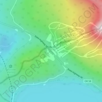
Name: Topografische Karte Willamette Pass, Höhe, Relief.
Ort: Willamette Pass, Klamath County, Oregon, United States (43.60050 -122.03797 43.60060 -122.03787)
Durchschnittliche Höhe: 1.605 m
Minimale Höhe: 1.438 m
Maximale Höhe: 2.014 m
Andere topografische Karten
Klicken Sie auf eine Karte, um ihre Topografie, ihre Höhe und ihr Relief anzuzeigen.
Deepest point -592m
United States > Oregon > Klamath County
Deepest point -592m, Klamath County, Oregon, United States
Durchschnittliche Höhe: 1.880 m
Link River
United States > Oregon > Klamath County > Klamath Falls
Link River, Klamath Falls, Klamath County, Oregon, United States
Durchschnittliche Höhe: 1.304 m
Chiloquin
United States > Oregon > Klamath County
Chiloquin, Klamath County, Oregon, United States
Durchschnittliche Höhe: 1.302 m
Crater Lake
United States > Oregon > Klamath County
Crater Lake, Klamath County, Oregon, United States
Durchschnittliche Höhe: 1.971 m
Crater Lake National Park
United States > Oregon > Klamath County
Crater Lake National Park, Klamath County, Oregon, 97604, United States
Durchschnittliche Höhe: 1.726 m
Klamath Falls
United States > Oregon > Klamath County
Klamath Falls, Klamath County, Oregon, 97601, United States
Durchschnittliche Höhe: 1.312 m