
Topografische Karte Crater Lake
Interaktive Karte
Klicken Sie auf die Karte, um die Höhe anzuzeigen.
Über diese Karte
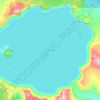
Name: Topografische Karte Crater Lake, Höhe, Relief.
Ort: Crater Lake, Klamath County, Oregon, United States (42.90431 -122.16453 42.97874 -122.04998)
Durchschnittliche Höhe: 1.971 m
Minimale Höhe: 1.853 m
Maximale Höhe: 2.483 m
The lake is 5 by 6 miles (8.0 by 9.7 km) across, with a caldera rim ranging in elevation from 7,000 to 8,000 feet (2,100 to 2,400 m) and an average lake depth of 1,148 feet (350 m). The lake's maximum depth has been measured at 1,949 feet (594 m), which fluctuates slightly as the weather changes. On the basis of maximum depth, Crater Lake is the deepest lake in the United States, the second-deepest in North America (after Great Slave Lake in Canada), and the ninth-deepest lake in the world. Crater Lake is often cited as the seventh-deepest lake in the world, but this ranking excludes Lake Vostok in Antarctica, which is beneath about 13,000 feet (4,000 m) of ice, and the recent depth soundings of O'Higgins/San Martín Lake, which is along the border of Chile and Argentina.
Andere topografische Karten
Klicken Sie auf eine Karte, um ihre Topografie, ihre Höhe und ihr Relief anzuzeigen.
Deepest point -592m
United States > Oregon > Klamath County
Deepest point -592m, Klamath County, Oregon, United States
Durchschnittliche Höhe: 1.880 m
Link River
United States > Oregon > Klamath County > Klamath Falls
Link River, Klamath Falls, Klamath County, Oregon, United States
Durchschnittliche Höhe: 1.304 m
Chiloquin
United States > Oregon > Klamath County
Chiloquin, Klamath County, Oregon, United States
Durchschnittliche Höhe: 1.302 m
Willamette Pass
United States > Oregon > Klamath County
Willamette Pass, Klamath County, Oregon, United States
Durchschnittliche Höhe: 1.605 m
Crater Lake National Park
United States > Oregon > Klamath County
Crater Lake National Park, Klamath County, Oregon, 97604, United States
Durchschnittliche Höhe: 1.726 m
Klamath Falls
United States > Oregon > Klamath County
Klamath Falls, Klamath County, Oregon, 97601, United States
Durchschnittliche Höhe: 1.312 m