
Topografische Karte Crater Lake National Park
Interaktive Karte
Klicken Sie auf die Karte, um die Höhe anzuzeigen.
Über diese Karte
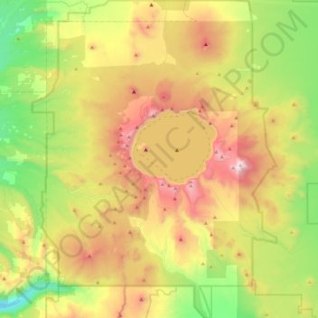
Name: Topografische Karte Crater Lake National Park, Höhe, Relief.
Durchschnittliche Höhe: 1.726 m
Minimale Höhe: 1.051 m
Maximale Höhe: 2.695 m
The caldera rim ranges in elevation from 7,000 to 8,000 feet (2,100 to 2,400 m). The United States Geological Survey benchmark elevation of the lake surface is 6,178 feet (1,883 m). The national park encompasses 183,224 acres (286.3 sq mi; 741.5 km2). Crater Lake has no streams flowing into or out of it. All water that enters the lake is eventually lost from evaporation or subsurface seepage. The lake's water commonly has a striking blue hue, and the lake is refilled entirely from direct precipitation in the form of snow and rain.
Andere topografische Karten
Klicken Sie auf eine Karte, um ihre Topografie, ihre Höhe und ihr Relief anzuzeigen.
Deepest point -592m
United States > Oregon > Klamath County
Deepest point -592m, Klamath County, Oregon, United States
Durchschnittliche Höhe: 1.880 m
Link River
United States > Oregon > Klamath County > Klamath Falls
Link River, Klamath Falls, Klamath County, Oregon, United States
Durchschnittliche Höhe: 1.304 m
Chiloquin
United States > Oregon > Klamath County
Chiloquin, Klamath County, Oregon, United States
Durchschnittliche Höhe: 1.302 m
Crater Lake
United States > Oregon > Klamath County
Crater Lake, Klamath County, Oregon, United States
Durchschnittliche Höhe: 1.971 m
Willamette Pass
United States > Oregon > Klamath County
Willamette Pass, Klamath County, Oregon, United States
Durchschnittliche Höhe: 1.605 m
Klamath Falls
United States > Oregon > Klamath County
Klamath Falls, Klamath County, Oregon, 97601, United States
Durchschnittliche Höhe: 1.312 m