
Topografische Karte Nebo
Interaktive Karte
Klicken Sie auf die Karte, um die Höhe anzuzeigen.
Über diese Karte
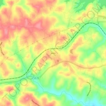
Name: Topografische Karte Nebo, Höhe, Relief.
Ort: Nebo, McDowell County, North Carolina, 28761, United States (35.69506 -81.95060 35.73506 -81.91060)
Durchschnittliche Höhe: 394 m
Minimale Höhe: 339 m
Maximale Höhe: 436 m
Andere topografische Karten
Klicken Sie auf eine Karte, um ihre Topografie, ihre Höhe und ihr Relief anzuzeigen.
West Marion
United States > North Carolina > McDowell County
West Marion, McDowell County, North Carolina, 28752, United States
Durchschnittliche Höhe: 449 m
Marion
United States > North Carolina > McDowell County
Marion, McDowell County, North Carolina, 28752, United States
Durchschnittliche Höhe: 435 m
Little Switzerland
United States > North Carolina > McDowell County
Little Switzerland, McDowell County, North Carolina, 28749, United States
Durchschnittliche Höhe: 935 m
Old Fort
United States > North Carolina > McDowell County
Old Fort, McDowell County, North Carolina, United States
Durchschnittliche Höhe: 474 m