
Topografische Karte Old Fort
Interaktive Karte
Klicken Sie auf die Karte, um die Höhe anzuzeigen.
Über diese Karte
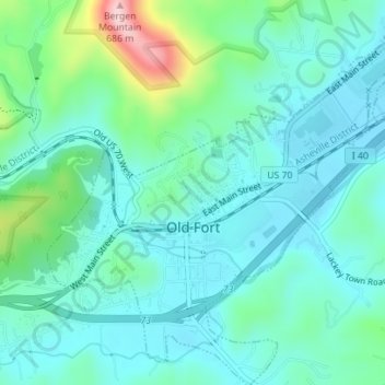
Name: Topografische Karte Old Fort, Höhe, Relief.
Ort: Old Fort, McDowell County, North Carolina, United States (35.61726 -82.19397 35.64572 -82.15928)
Durchschnittliche Höhe: 474 m
Minimale Höhe: 422 m
Maximale Höhe: 672 m
Andere topografische Karten
Klicken Sie auf eine Karte, um ihre Topografie, ihre Höhe und ihr Relief anzuzeigen.
West Marion
United States > North Carolina > McDowell County
West Marion, McDowell County, North Carolina, 28752, United States
Durchschnittliche Höhe: 449 m
Marion
United States > North Carolina > McDowell County
Marion, McDowell County, North Carolina, 28752, United States
Durchschnittliche Höhe: 435 m
Nebo
United States > North Carolina > McDowell County
Nebo, McDowell County, North Carolina, 28761, United States
Durchschnittliche Höhe: 394 m
Little Switzerland
United States > North Carolina > McDowell County
Little Switzerland, McDowell County, North Carolina, 28749, United States
Durchschnittliche Höhe: 935 m