
Topografische Karte Little Switzerland
Interaktive Karte
Klicken Sie auf die Karte, um die Höhe anzuzeigen.
Über diese Karte
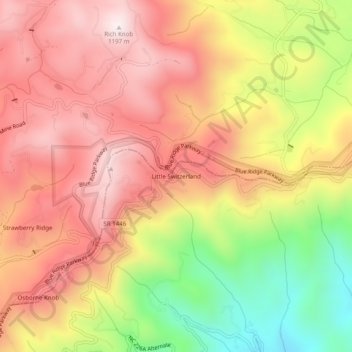
Name: Topografische Karte Little Switzerland, Höhe, Relief.
Durchschnittliche Höhe: 935 m
Minimale Höhe: 554 m
Maximale Höhe: 1.196 m
Little Switzerland is an unincorporated community in McDowell and Mitchell counties of North Carolina, United States. It is located along North Carolina Highway 226A (NC 226A) off the Blue Ridge Parkway, directly north of Marion and south of Spruce Pine. The elevation is 3,468 feet (1,057 m) above sea level.
Andere topografische Karten
Klicken Sie auf eine Karte, um ihre Topografie, ihre Höhe und ihr Relief anzuzeigen.
West Marion
United States > North Carolina > McDowell County
West Marion, McDowell County, North Carolina, 28752, United States
Durchschnittliche Höhe: 449 m
Marion
United States > North Carolina > McDowell County
Marion, McDowell County, North Carolina, 28752, United States
Durchschnittliche Höhe: 435 m
Nebo
United States > North Carolina > McDowell County
Nebo, McDowell County, North Carolina, 28761, United States
Durchschnittliche Höhe: 394 m
Old Fort
United States > North Carolina > McDowell County
Old Fort, McDowell County, North Carolina, United States
Durchschnittliche Höhe: 474 m