
Topografische Karte Mannarkkad
Interaktive Karte
Klicken Sie auf die Karte, um die Höhe anzuzeigen.
Über diese Karte
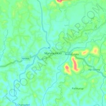
Name: Topografische Karte Mannarkkad, Höhe, Relief.
Durchschnittliche Höhe: 80 m
Minimale Höhe: 47 m
Maximale Höhe: 201 m
Mannarkkad is located at 10°59′N 76°28′E / 10.98°N 76.47°E / 10.98; 76.47. It has an average elevation of 76 m (249 ft). Mannarkkad is located 36 km north-west of district headquarters Palakkad, along National Highway 966 and 100 km north west of Kozhikode. Mannarkkad is located in the foothills of the Western Ghats.
Andere topografische Karten
Klicken Sie auf eine Karte, um ihre Topografie, ihre Höhe und ihr Relief anzuzeigen.
Kottathara
Kottathara, Mannarkad, Palakkad District, Kerala, India
Durchschnittliche Höhe: 549 m
Silent Valley National Park
Silent Valley National Park, Mannarkad, Palakkad district, Kerala, India
Durchschnittliche Höhe: 1.103 m
Kalladikode
Kalladikode, Mannarkad, Palakkad District, Kerala, 678596, India
Durchschnittliche Höhe: 101 m