
Topografische Karte Province of Oxapampa
Interaktive Karte
Klicken Sie auf die Karte, um die Höhe anzuzeigen.
Über diese Karte
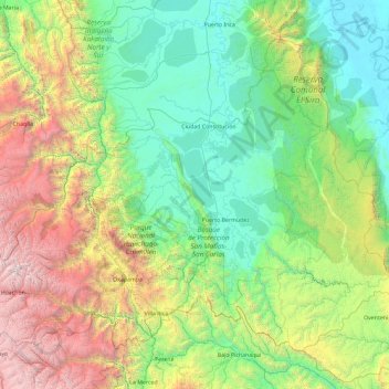
Name: Topografische Karte Province of Oxapampa, Höhe, Relief.
Ort: Province of Oxapampa, Pasco, 19230, Peru (-10.91260 -75.98550 -9.44570 -74.13203)
Durchschnittliche Höhe: 1.348 m
Minimale Höhe: 152 m
Maximale Höhe: 5.332 m
The Oxapampa Province (Spanish: Provincia de Oxapampa) is the largest of three provinces that make up the Pasco Region in Peru. The capital of the Oxapampa province is the city of Oxapampa. The province is located on the eastern slopes of the Andes reaching down to the lowlands of the Amazon Basin. The high point of the province is approximately 5,300 metres (17,400 ft) in elevation near the summit of Huaguruncho mountain in the Huancabamba District and the low point is approximately 200 metres (660 ft) on the Pachitea River in the Constitución District.
Andere topografische Karten
Klicken Sie auf eine Karte, um ihre Topografie, ihre Höhe und ihr Relief anzuzeigen.
Orellana
Peru > Pasco > Constitución
Orellana, Constitución, Province of Oxapampa, Pasco, Peru
Durchschnittliche Höhe: 241 m
Cerro de Pasco
Cerro de Pasco, Chaupimarca, Province of Pasco, Pasco, Peru
Durchschnittliche Höhe: 4.239 m
Villo
Peru > Pasco > Yanahuanca
Villo, Yanahuanca, Province of Daniel Carrión, Pasco, Peru
Durchschnittliche Höhe: 3.764 m