
Topografische Karte Rocco
Interaktive Karte
Klicken Sie auf die Karte, um die Höhe anzuzeigen.
Über diese Karte
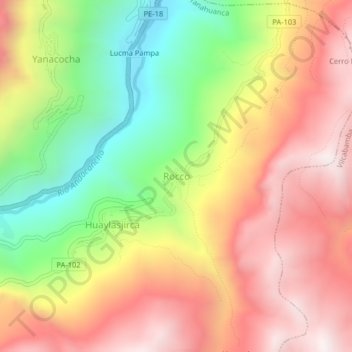
Name: Topografische Karte Rocco, Höhe, Relief.
Ort: Rocco, Yanahuanca, Province of Daniel Carrión, Pasco, Peru (-10.50463 -76.50744 -10.46463 -76.46744)
Durchschnittliche Höhe: 3.648 m
Minimale Höhe: 2.996 m
Maximale Höhe: 4.221 m
Andere topografische Karten
Klicken Sie auf eine Karte, um ihre Topografie, ihre Höhe und ihr Relief anzuzeigen.
Province of Oxapampa
Province of Oxapampa, Pasco, 19230, Peru
Durchschnittliche Höhe: 1.348 m
Orellana
Peru > Pasco > Constitución
Orellana, Constitución, Province of Oxapampa, Pasco, Peru
Durchschnittliche Höhe: 241 m
Cerro de Pasco
Cerro de Pasco, Chaupimarca, Province of Pasco, Pasco, Peru
Durchschnittliche Höhe: 4.239 m
Villo
Peru > Pasco > Yanahuanca
Villo, Yanahuanca, Province of Daniel Carrión, Pasco, Peru
Durchschnittliche Höhe: 3.764 m