
Topografische Karte Cerro de Pasco
Interaktive Karte
Klicken Sie auf die Karte, um die Höhe anzuzeigen.
Über diese Karte
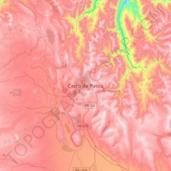
Name: Topografische Karte Cerro de Pasco, Höhe, Relief.
Durchschnittliche Höhe: 4.239 m
Minimale Höhe: 3.386 m
Maximale Höhe: 4.602 m
Cerro de Pasco is a city in central Peru, located at the top of the Andean Mountains. It is the capital of both the Pasco Province and the Department of Pasco, and an important mining center of silver, copper, zinc and lead. At an elevation of 4,330 metres (14,210 ft), it is one of the highest cities in the world, and with a population of 58,899, it is the highest or the second highest city with over 50,000 inhabitants. The elevation reaches up to 4,380 metres or 14,370 feet in the Yanacancha area. The city has a very intense cold climate and it is connected by road and by rail (via Ferrocarril Central Andino) to the capital Lima, 300 kilometres or 190 miles away. Its urban area is formed by the districts of Chaupimarca, Yanacancha and Simón Bolívar.
Andere topografische Karten
Klicken Sie auf eine Karte, um ihre Topografie, ihre Höhe und ihr Relief anzuzeigen.
Province of Oxapampa
Province of Oxapampa, Pasco, 19230, Peru
Durchschnittliche Höhe: 1.348 m
Orellana
Peru > Pasco > Constitución
Orellana, Constitución, Province of Oxapampa, Pasco, Peru
Durchschnittliche Höhe: 241 m
Villo
Peru > Pasco > Yanahuanca
Villo, Yanahuanca, Province of Daniel Carrión, Pasco, Peru
Durchschnittliche Höhe: 3.764 m