Geolokalisieren
👉 Easily get elevation data in JSON, GeoTIFF and KML formats using Elevation API
Vielen Dank für die Unterstützung dieser Website ❤️
Spenden

Rüsten Sie sich für Ihr nächstes Abenteuer:

Als Amazon-Partner verdient diese Website an qualifizierten Käufen, ohne dass Ihnen zusätzliche Kosten entstehen.

Topografische Karte Ernad

Klicken Sie auf die Karte, um die Höhe anzuzeigen.

👉 Easily get elevation data in JSON, GeoTIFF and KML formats using Elevation API
Vielen Dank für die Unterstützung dieser Website ❤️
Spenden

Rüsten Sie sich für Ihr nächstes Abenteuer:

Als Amazon-Partner verdient diese Website an qualifizierten Käufen, ohne dass Ihnen zusätzliche Kosten entstehen.

Über diese Karte

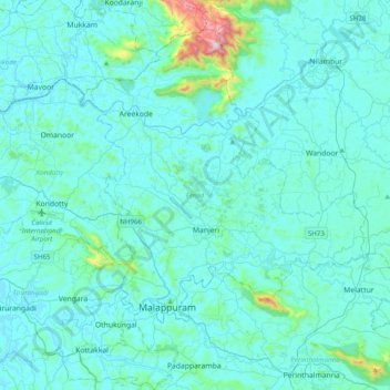
Name: Topografische Karte Ernad, Höhe, Relief.

Ort: Ernad, Malappuram District, Kerala, India (10.96096 75.98762 11.34651 76.28218)

Durchschnittliche Höhe: 75 m

Minimale Höhe: 0 m

Maximale Höhe: 952 m

👉 Easily get elevation data in JSON, GeoTIFF and KML formats using Elevation API
Vielen Dank für die Unterstützung dieser Website ❤️
Spenden

Andere topografische Karten

Klicken Sie auf eine Karte, um ihre Topografie, ihre Höhe und ihr Relief anzuzeigen.

Kochi

India > Kerala > Kochi

Durchschnittliche Höhe: 4 m

Western Ghats

India > Kerala > Devikulam

The range starts near south of the Tapti river and runs approximately 1,600 km (990 mi) through the states of Gujarat, Maharashtra, Karnataka, Goa, Kerala and Tamil Nadu ending at Marunthuvazh Malai, Swamithope near the southern tip of India. These hills cover 160,000 km2 (62,000 sq mi) and form the catchment…

Durchschnittliche Höhe: 2.225 m

Thiruvananthapuram

India > Kerala > Thiruvananthapuram

Thiruvananthapuram is built on seven hills by the seashore and is at 8°30′N 76°54′E / 8.5°N 76.9°E / 8.5; 76.9 on the west coast, near the southern tip of mainland India. The city is on the west coast of India and is bounded by the Laccadive Sea to its west and the Western Ghats to its east.…

Durchschnittliche Höhe: 33 m

Irinjalakuda

India > Kerala > Mukundapuram

Durchschnittliche Höhe: 7 m

Vielen Dank für die Unterstützung dieser Website ❤️
Spenden

Rüsten Sie sich für Ihr nächstes Abenteuer:

Als Amazon-Partner verdient diese Website an qualifizierten Käufen, ohne dass Ihnen zusätzliche Kosten entstehen.

Panthamakkal

India > Kerala > Kanjirappally

Durchschnittliche Höhe: 100 m

Kollam

India > Kerala > Kollam

Cosmas Indicopleustes, a Greek Nestorian sailor, in his book the Christian Topography who visited the Malabar Coast in 550, mentions an enclave of Christian believers in Male (Malabar Coast). He writes, "In the island of Tabropane (Ceylon), there is a church of Christians, and clerics and faithful. Likewise at…

Durchschnittliche Höhe: 11 m

Kottathara

India > Kerala

Durchschnittliche Höhe: 738 m

Vaduvanchal

India > Kerala

Durchschnittliche Höhe: 858 m

Vielen Dank für die Unterstützung dieser Website ❤️
Spenden

Manarcadu

India > Kerala > Kottayam

Durchschnittliche Höhe: 23 m

Gurukula Botanical Sanctuary

India > Kerala > Mananthavady > Periya

Durchschnittliche Höhe: 756 m

Pallikkara

India > Kerala > Kunnathunad

Durchschnittliche Höhe: 12 m

Mundakai

India > Kerala

Durchschnittliche Höhe: 1.020 m

Vielen Dank für die Unterstützung dieser Website ❤️
Spenden

Chooralmala

India > Kerala

Durchschnittliche Höhe: 854 m

Anamudi

India > Kerala > Devikulam

Anamudi ("Elephant head") is a mountain located in Ernakulam district and Idukki district of the Indian state of Kerala. With an elevation of 2,695 metres (8,842 ft) and a topographic prominence of 2,479 metres (8,133 ft), it is the highest peak in the Western Ghats and in South India.

Durchschnittliche Höhe: 2.209 m

Pandalam

India > Kerala > Adoor

Durchschnittliche Höhe: 20 m

Koottar

India > Kerala > Udumbanchola

Durchschnittliche Höhe: 967 m

Vielen Dank für die Unterstützung dieser Website ❤️
Spenden

Rüsten Sie sich für Ihr nächstes Abenteuer:

Als Amazon-Partner verdient diese Website an qualifizierten Käufen, ohne dass Ihnen zusätzliche Kosten entstehen.

Cheppad

India > Kerala > Karthikappally

Durchschnittliche Höhe: 7 m

Kumarapuram

India > Kerala > Karthikappally

Durchschnittliche Höhe: 5 m

Kainoor

India > Kerala > Thrissur

Durchschnittliche Höhe: 22 m

Iruvazhinji

India > Kerala > Kozhikode

Durchschnittliche Höhe: 44 m

Vielen Dank für die Unterstützung dieser Website ❤️
Spenden

Rüsten Sie sich für Ihr nächstes Abenteuer:

Als Amazon-Partner verdient diese Website an qualifizierten Käufen, ohne dass Ihnen zusätzliche Kosten entstehen.

Pothiyil thottiparamba

India > Kerala > Perinthalmanna > Poovathani

Durchschnittliche Höhe: 71 m

Choondal

India > Kerala > Kunnamkulam

Durchschnittliche Höhe: 12 m

Vettinad

India > Kerala > Nedumangad

Durchschnittliche Höhe: 61 m

Blathur

India > Kerala > Iritty

Durchschnittliche Höhe: 131 m

Vielen Dank für die Unterstützung dieser Website ❤️
Spenden

Rüsten Sie sich für Ihr nächstes Abenteuer:

Als Amazon-Partner verdient diese Website an qualifizierten Käufen, ohne dass Ihnen zusätzliche Kosten entstehen.

Mayannur

India > Kerala > Talappilly

Durchschnittliche Höhe: 53 m

cheriyanad

India > Kerala > Chengannur

Durchschnittliche Höhe: 9 m

Pattithanam

India > Kerala > Meenachil

Pattithanam is a village near Ettumanoor in the Kottayam District of Kerala, India. The name 'Pattithanam' is believed to be given by the Portuguese traders, who were looking for an ideal spot to build a church (St.Boniface Church). Pattithanam(Pattia Sthanam) means ideal place in Malayalam. Pattithanam…

Durchschnittliche Höhe: 38 m

Kalpetta

India > Kerala > Vythiri

Kalpetta is a city and town and Wayanad Grade 2 municipality in the Wayanad district of the Indian state of Kerala. Kalpetta is the headquarters of the Wayanad district, as well as the headquarters of Vythiri taluk. It is surrounded by dense coffee and tea plantations and mountains. It lies on the…

Durchschnittliche Höhe: 809 m

Vielen Dank für die Unterstützung dieser Website ❤️
Spenden

Kainakary

India > Kerala > Kuttanad

Durchschnittliche Höhe: 2 m

Sringapuram

India > Kerala > Kodungallur

Durchschnittliche Höhe: 6 m

Mylom

India > Kerala > Kottarakkara

Durchschnittliche Höhe: 41 m

Perinthalmanna

India > Kerala > Perinthalmanna

Durchschnittliche Höhe: 76 m

Pullikkanam

India > Kerala > Peerumade

Durchschnittliche Höhe: 740 m

Peroorthodu

India > Kerala > Kanjirappally

Durchschnittliche Höhe: 111 m

Velli Kulangara

India > Kerala > Mukundapuram

Durchschnittliche Höhe: 8 m

Manchira

India > Kerala > Chittur

Durchschnittliche Höhe: 121 m

Kulangara colony

India > Kerala > Vaikom > Thalayolaparambu

Durchschnittliche Höhe: 6 m

Pathanapuram

India > Kerala > Pathanapuram

Durchschnittliche Höhe: 57 m

Elappully

India > Kerala > Palakkad

Durchschnittliche Höhe: 111 m

Mannar

India > Kerala > Chengannur

Durchschnittliche Höhe: 6 m

Vielen Dank für die Unterstützung dieser Website ❤️
Spenden

Rüsten Sie sich für Ihr nächstes Abenteuer:

Als Amazon-Partner verdient diese Website an qualifizierten Käufen, ohne dass Ihnen zusätzliche Kosten entstehen.

Mannarkkad

India > Kerala > Mannarkad

Mannarkkad is located at 10°59′N 76°28′E / 10.98°N 76.47°E / 10.98; 76.47. It has an average elevation of 76 m (249 ft). Mannarkkad is located 36 km north-west of district headquarters Palakkad, along National Highway 966 and 100 km north west of Kozhikode. Mannarkkad is located in the…

Durchschnittliche Höhe: 80 m

Kodanad

India > Kerala > Kunnathunad

Durchschnittliche Höhe: 19 m

Kadalundi

India > Kerala > Kozhikode

Durchschnittliche Höhe: 13 m

Pattambi

India > Kerala > Pattambi

Durchschnittliche Höhe: 37 m

Vielen Dank für die Unterstützung dieser Website ❤️
Spenden

Vilangupara

India > Kerala > Meenachil > Bharananganam

Durchschnittliche Höhe: 35 m

Anaimudi River

India > Kerala > Devikulam

Durchschnittliche Höhe: 1.430 m

Kattangal

India > Kerala > Kozhikode

Durchschnittliche Höhe: 41 m

Areekkuzhi

India > Kerala > Koyilandi > Karumala

Durchschnittliche Höhe: 45 m

Perumbala

India > Kerala > Kasaragod

Durchschnittliche Höhe: 36 m

Chettuva

India > Kerala > Chavakkad

Durchschnittliche Höhe: 3 m

Puthanathani

India > Kerala > Tirur

Durchschnittliche Höhe: 83 m

Meenangadi

India > Kerala > Sulthanbathery

Durchschnittliche Höhe: 760 m

Vengoor

India > Kerala > Aluva

Durchschnittliche Höhe: 15 m

Hill Top View Point

India > Kerala > Devikulam > Pallivasal

Durchschnittliche Höhe: 1.443 m

Kannur

India > Kerala > Kannur > Kannur

Kannur has an elevation of 1.02 metres or 3.3 feet along the coast of the Laccadive Sea, with a sandy coastal area. The city has an 8 kilometres (5.0 mi)-long seashore and a 3 kilometres (1.9 mi)-long beach at Payyambalam. Kannur is located north of Kozhikode, south of Kasargod and Mangalore, west of the…

Durchschnittliche Höhe: 13 m

Kozhikode

India > Kerala > Kozhikode

Durchschnittliche Höhe: 14 m

Pathanamthitta

India > Kerala

Pathanamthitta has an average elevation of 18 metres (62 ft) above sea level.

Durchschnittliche Höhe: 63 m

Thrissur

India > Kerala > Thrissur

Thrissur is the headquarters of Thrissur district, in the centre of the Indian state of Kerala. The city is 75 km north-east of Kochi, 133 km south-west of Coimbatore, 124 km south-east of Kozhikode and 151 km north of Changanacherry. The city is located in a hillock called Thekkinkadu Maidan which is the…

Durchschnittliche Höhe: 36 m

Chaliyar River

India > Kerala

Durchschnittliche Höhe: 60 m

Meenachil River

India > Kerala

Durchschnittliche Höhe: 31 m

Vielen Dank für die Unterstützung dieser Website ❤️
Spenden

Rüsten Sie sich für Ihr nächstes Abenteuer:

Als Amazon-Partner verdient diese Website an qualifizierten Käufen, ohne dass Ihnen zusätzliche Kosten entstehen.

Willingdon Island

India > Kerala > Kochi > Kochi

Durchschnittliche Höhe: 4 m

Pettamala

India > Kerala > Kunnathunad

Durchschnittliche Höhe: 23 m

Cheruthuruthy

India > Kerala > Talappilly

Durchschnittliche Höhe: 37 m

Valakom

India > Kerala > Muvattupuzha

Durchschnittliche Höhe: 23 m

Vielen Dank für die Unterstützung dieser Website ❤️
Spenden

Rüsten Sie sich für Ihr nächstes Abenteuer:

Als Amazon-Partner verdient diese Website an qualifizierten Käufen, ohne dass Ihnen zusätzliche Kosten entstehen.

Kidangannur

India > Kerala > Kozhencherry

Durchschnittliche Höhe: 25 m

Kanjirakolly

India > Kerala > Taliparamba

Durchschnittliche Höhe: 421 m

Malankara Dam

India > Kerala > Thodupuzha > Muttam

Durchschnittliche Höhe: 59 m

Kumbanad

India > Kerala > Thiruvalla

Durchschnittliche Höhe: 24 m

Palliyol pothu Kulam

India > Kerala > Kozhikode > Mavoor

Durchschnittliche Höhe: 26 m

Kalikavu

India > Kerala > Meenachil

Durchschnittliche Höhe: 34 m

Pattom Palace

India > Kerala > Thiruvananthapuram > Thiruvananthapuram

Durchschnittliche Höhe: 26 m

Mankara

India > Kerala > Palakkad

Durchschnittliche Höhe: 65 m

Vallakkunnu

India > Kerala > Chalakkudy

Durchschnittliche Höhe: 10 m

Thalayolaparambu

India > Kerala > Vaikom

Durchschnittliche Höhe: 10 m

Mattannur

India > Kerala > Thalassery

Durchschnittliche Höhe: 59 m

Melmury

India > Kerala

Durchschnittliche Höhe: 925 m

Koodaranji

India > Kerala > Thamarassery

Durchschnittliche Höhe: 98 m

Anachal

India > Kerala > Devikulam

Durchschnittliche Höhe: 1.006 m

Manimala River

India > Kerala > Kottayam > Eravinalloor

Durchschnittliche Höhe: 12 m

Bison Valley

India > Kerala > Udumbanchola

Durchschnittliche Höhe: 1.047 m

Vielen Dank für die Unterstützung dieser Website ❤️
Spenden

Rüsten Sie sich für Ihr nächstes Abenteuer:

Als Amazon-Partner verdient diese Website an qualifizierten Käufen, ohne dass Ihnen zusätzliche Kosten entstehen.

Kavalam

India > Kerala > Kuttanad

Durchschnittliche Höhe: 3 m

Tirur

India > Kerala > Tirur

Tirur is a major trading centre for electronic devices and seafood in Northern Kerala and has an average elevation of 2 metres (6 ft 7 in) above the sea level.

Durchschnittliche Höhe: 15 m

Thodupuzha

India > Kerala > Thodupuzha

Durchschnittliche Höhe: 53 m

Ayoor

India > Kerala > Punalur

Durchschnittliche Höhe: 70 m

Vielen Dank für die Unterstützung dieser Website ❤️
Spenden

Rüsten Sie sich für Ihr nächstes Abenteuer:

Als Amazon-Partner verdient diese Website an qualifizierten Käufen, ohne dass Ihnen zusätzliche Kosten entstehen.

Chaliyangod

India > Kerala > Kasaragod

Durchschnittliche Höhe: 23 m

Tanur

India > Kerala > Tirur

Tanur is located at 10°58′N 75°52′E / 10.97°N 75.87°E / 10.97; 75.87. It has an average elevation of 1 m (3.3 ft).

Durchschnittliche Höhe: 8 m

Vengara

India > Kerala > Tirurangadi

Durchschnittliche Höhe: 59 m

Chembra peak

India > Kerala > Thamarassery > Vythiri

Durchschnittliche Höhe: 1.628 m

Vielen Dank für die Unterstützung dieser Website ❤️
Spenden

Rüsten Sie sich für Ihr nächstes Abenteuer:

Als Amazon-Partner verdient diese Website an qualifizierten Käufen, ohne dass Ihnen zusätzliche Kosten entstehen.

Kannankode

India > Kerala > Kottarakkara

Durchschnittliche Höhe: 77 m

Eachome

India > Kerala > Mananthavady

Durchschnittliche Höhe: 749 m

Meenachil

India > Kerala > Kottayam > Pulikuttisseri

Durchschnittliche Höhe: 7 m

Cherai

India > Kerala > Kochi

Durchschnittliche Höhe: 3 m

Vielen Dank für die Unterstützung dieser Website ❤️
Spenden

Rüsten Sie sich für Ihr nächstes Abenteuer:

Als Amazon-Partner verdient diese Website an qualifizierten Käufen, ohne dass Ihnen zusätzliche Kosten entstehen.

Maniyur

India > Kerala > Vadakara

Durchschnittliche Höhe: 19 m

Vellaramkunnu

India > Kerala > Peerumade

Durchschnittliche Höhe: 1.030 m

Kundayithode

India > Kerala > Kozhikode

Durchschnittliche Höhe: 13 m

Vielen Dank für die Unterstützung dieser Website ❤️
Spenden

Rüsten Sie sich für Ihr nächstes Abenteuer:

Als Amazon-Partner verdient diese Website an qualifizierten Käufen, ohne dass Ihnen zusätzliche Kosten entstehen.

Mukkam

India > Kerala > Kozhikode

Durchschnittliche Höhe: 50 m

Vellarimala

India > Kerala > Thamarassery > Vythiri

Durchschnittliche Höhe: 1.773 m

Pavukkonam

India > Kerala > Ottappalam

Durchschnittliche Höhe: 75 m

East Mattukkatta

India > Kerala > Idukki > Vellilamkandam

Durchschnittliche Höhe: 831 m

Rüsten Sie sich für Ihr nächstes Abenteuer:

🚲Fahrrad GPS - Navigation für Radfahren
🥽Sonnenbrille UV - Schutz vor UV-Strahlen beim Bergwandern
🪓Multitool - Vielseitiges Werkzeug für Outdoor
🔦LED Fahrradlicht Set - StVZO-konforme Beleuchtung für Sicherheit bei Nacht
🧥Hardshelljacke Herren - Extremer Wetterschutz für Alpinisten

Als Amazon-Partner verdient diese Website an qualifizierten Käufen, ohne dass Ihnen zusätzliche Kosten entstehen.