Geolokalisieren

Topografische Karte Cahersiveen

Interaktive Karte

Klicken Sie auf die Karte, um die Höhe anzuzeigen.

Über diese Karte

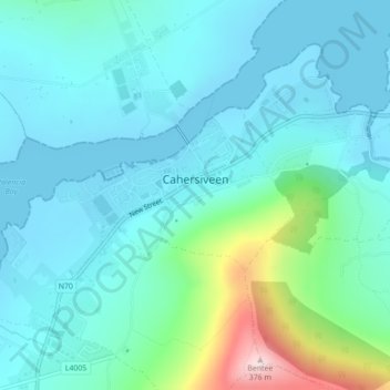
Name: Topografische Karte Cahersiveen, Höhe, Relief.

Ort: Cahersiveen, County Kerry, Munster, V23 FF95, Ireland (51.93768 -10.24312 51.95438 -10.20588)

Durchschnittliche Höhe: 66 m

Minimale Höhe: -1 m

Maximale Höhe: 369 m

Andere topografische Karten

Klicken Sie auf eine Karte, um ihre Topografie, ihre Höhe und ihr Relief anzuzeigen.

Aughacasla

Ireland > County Kerry

Aughacasla, Kenmare Municipal District, County Kerry, Munster, V92 YD42, Ireland

Durchschnittliche Höhe: 24 m

Sneem

Ireland > County Kerry

Sneem, County Kerry, Munster, Ireland

Durchschnittliche Höhe: 23 m

Kilflynn

Ireland > County Kerry

Kilflynn, Listowel Municipal District, County Kerry, Munster, Ireland

Durchschnittliche Höhe: 69 m

Ballyspillane

Ireland > County Kerry > Killarney

Ballyspillane, Killarney, Killarney Municipal District, County Kerry, Munster, Ireland

Durchschnittliche Höhe: 71 m

Boolacullane

Ireland > County Kerry

Boolacullane, Molahiffe ED, Tralee Municipal District, County Kerry, Munster, Ireland

Durchschnittliche Höhe: 113 m

Carrauntoohil

Ireland > County Kerry

Carrauntoohil, Kenmare Municipal District, County Kerry, Munster, V93 A8N1, Ireland

Durchschnittliche Höhe: 644 m

Beara

Ireland > County Kerry

Beara, County Kerry, Munster, Ireland

Durchschnittliche Höhe: 108 m

Ballybunion

Ireland > County Kerry

Ballybunion, County Kerry, Munster, Ireland

Durchschnittliche Höhe: 28 m

Cloon

Ireland > County Kerry

Cloon, Emlagh ED, Kenmare Municipal District, County Kerry, Munster, Ireland

Durchschnittliche Höhe: 25 m

Tralee

Ireland > County Kerry

Tralee, County Kerry, Munster, Ireland

Durchschnittliche Höhe: 22 m

Ballyseedy Wood

Ireland > County Kerry

Ballyseedy Wood, Ballyseedy ED, Tralee Municipal District, County Kerry, Munster, Ireland

Durchschnittliche Höhe: 20 m

Shronowen

Ireland > County Kerry

Shronowen, Shronowen ED, Listowel Municipal District, County Kerry, Munster, Ireland

Durchschnittliche Höhe: 27 m

Torc Mountain

Ireland > County Kerry

Torc Mountain, Killarney Municipal District, County Kerry, Munster, V93 RR59, Ireland

Durchschnittliche Höhe: 202 m

Farranfore

Ireland > County Kerry

Farranfore, Tralee Municipal District, County Kerry, Munster, V93 YP44, Ireland

Durchschnittliche Höhe: 59 m

Lisselton

Ireland > County Kerry

Lisselton, Listowel Municipal District, County Kerry, Munster, Ireland

Durchschnittliche Höhe: 34 m

Stradbally Mountain

Ireland > County Kerry

Stradbally Mountain, Kenmare Municipal District, County Kerry, Munster, Ireland

Durchschnittliche Höhe: 487 m

Glencar

Ireland > County Kerry

Glencar, Kenmare Municipal District, County Kerry, Munster, Ireland

Durchschnittliche Höhe: 114 m

Kilgarvan

Ireland > County Kerry

Kilgarvan, Kilgarvan ED, Kenmare Municipal District, County Kerry, Munster, Ireland

Durchschnittliche Höhe: 71 m

Dingle

Ireland > County Kerry

Dingle, County Kerry, Munster, Ireland

Durchschnittliche Höhe: 41 m

Brosna

Ireland > County Kerry

Brosna, Tralee Municipal District, County Kerry, Munster, Ireland

Durchschnittliche Höhe: 163 m

Killarney

Ireland > County Kerry

Killarney, Killarney Municipal District, County Kerry, Munster, Ireland

Durchschnittliche Höhe: 57 m

Lispole

Ireland > County Kerry

Lispole, Kenmare Municipal District, County Kerry, Munster, V92 DN23, Ireland

Durchschnittliche Höhe: 107 m

Rathmore

Ireland > County Kerry

Rathmore, Rathmore ED, Killarney Municipal District, County Kerry, Munster, P51 PT66, Ireland

Durchschnittliche Höhe: 149 m

Killorglin

Ireland > County Kerry

Killorglin, Killorglin ED, Kenmare Municipal District, County Kerry, Munster, Ireland

Durchschnittliche Höhe: 23 m

Kilcummin

Ireland > County Kerry

Kilcummin, Kilcummin ED, Killarney Municipal District, County Kerry, Munster, Ireland

Durchschnittliche Höhe: 142 m

Cromane Upper

Ireland > County Kerry

Cromane Upper, Killorglin ED, Kenmare Municipal District, County Kerry, Munster, Ireland

Durchschnittliche Höhe: 18 m

Lyreboy

Ireland > County Kerry

Lyreboy, Maum ED, Kenmare Municipal District, County Kerry, Munster, Ireland

Durchschnittliche Höhe: 342 m

Killarney

Ireland > County Kerry

Killarney, Killarney Urban ED, Killarney Municipal District, County Kerry, Munster, Ireland

Durchschnittliche Höhe: 39 m

Glenmore

Ireland > County Kerry

Glenmore, Glanmore ED, Kenmare Municipal District, County Kerry, Munster, Ireland

Durchschnittliche Höhe: 269 m

Killarney

Ireland > County Kerry > Killarney

Killarney, Killarney Municipal District, County Kerry, Munster, V93 AYP9, Ireland

Durchschnittliche Höhe: 66 m

Tralee

Ireland > County Kerry

Tralee, County Kerry, Munster, Ireland

Durchschnittliche Höhe: 20 m

Glanmore

Ireland > County Kerry

Glanmore, Kilgobban ED, Kenmare Municipal District, County Kerry, Munster, Ireland

Durchschnittliche Höhe: 187 m

Beheenagh

Ireland > County Kerry

Beheenagh, Kilgobban ED, Kenmare Municipal District, County Kerry, Munster, Ireland

Durchschnittliche Höhe: 347 m

Banna Strand

Ireland > County Kerry

Banna Strand, Banna ED, Tralee Municipal District, County Kerry, Munster, Ireland

Durchschnittliche Höhe: 4 m

Lauragh

Ireland > County Kerry

Lauragh, Kenmare Municipal District, County Kerry, Munster, Ireland

Durchschnittliche Höhe: 89 m

Derrybanane

Ireland > County Kerry

Derrybanane, Flesk ED, Killarney Municipal District, County Kerry, Munster, Ireland

Durchschnittliche Höhe: 299 m

Valencia Island

Ireland > County Kerry

Valencia Island, Kenmare Municipal District, County Kerry, Munster, Ireland

Durchschnittliche Höhe: 39 m

Glashanacree

Ireland > County Kerry

Glashanacree, Kilshenane ED, Tralee Municipal District, County Kerry, Munster, Ireland

Durchschnittliche Höhe: 143 m

Barrow

Ireland > County Kerry

Barrow, Ballynahaglish ED, Tralee Municipal District, County Kerry, Munster, Ireland

Durchschnittliche Höhe: 7 m

Aghadoe

Ireland > County Kerry

Aghadoe, County Kerry, Munster, Ireland

Durchschnittliche Höhe: 132 m

Lough Guitane

Ireland > County Kerry

Lough Guitane, Flesk ED, Killarney Municipal District, County Kerry, Munster, Ireland

Durchschnittliche Höhe: 112 m

Knoppoge

Ireland > County Kerry

Knoppoge, Ballyduff ED, Listowel Municipal District, County Kerry, Munster, Ireland

Durchschnittliche Höhe: 29 m

Gunsborough

Ireland > County Kerry

Gunsborough, Gunsborough ED, Listowel Municipal District, County Kerry, Munster, V31 TR74, Ireland

Durchschnittliche Höhe: 54 m

Knocknacree

Ireland > County Kerry

Knocknacree, Ballyduff ED, Listowel Municipal District, County Kerry, Munster, Ireland

Durchschnittliche Höhe: 51 m

Barraduff

Ireland > County Kerry > Barraduff

Barraduff, Killarney Municipal District, County Kerry, Munster, Ireland

Durchschnittliche Höhe: 124 m

Pallis

Ireland > County Kerry

Pallis, Lahard ED, Killarney Municipal District, County Kerry, Munster, Ireland

Durchschnittliche Höhe: 48 m

Ballincolla

Ireland > County Kerry

Ballincolla, Dunurlin ED, Kenmare Municipal District, County Kerry, Munster, Ireland

Durchschnittliche Höhe: 22 m

Rattoo Round Tower

Ireland > County Kerry

Rattoo Round Tower, R551, Ballyduff ED, Listowel Municipal District, County Kerry, Munster, Ireland

Durchschnittliche Höhe: 16 m

Knockbrack

Ireland > County Kerry

Knockbrack, Ballynorig ED, Listowel Municipal District, County Kerry, Munster, Ireland

Durchschnittliche Höhe: 20 m

Heirhill

Ireland > County Kerry

Heirhill, Ballyheige ED, Listowel Municipal District, County Kerry, Munster, Ireland

Durchschnittliche Höhe: 54 m