
Topografische Karte Idaho
Interaktive Karte
Klicken Sie auf die Karte, um die Höhe anzuzeigen.
Über diese Karte
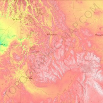
Name: Topografische Karte Idaho, Höhe, Relief.
Ort: Idaho, United States (41.98883 -117.24303 49.00084 -111.04356)
Durchschnittliche Höhe: 1.533 m
Minimale Höhe: 102 m
Maximale Höhe: 4.034 m
Idaho's climate varies widely. Although the state's western border is about 330 miles (530 km) from the Pacific Ocean, the maritime influence is still felt in Idaho; especially, in the winter when cloud cover, humidity, and precipitation are at their maximum extent. This influence has a moderating effect in the winter where temperatures are not as low as would otherwise be expected for a northern state with predominantly high elevations. In the panhandle, moist air masses from the coast are released as precipitation over the North Central Rockies forests, creating the North American inland temperate rainforest. The maritime influence is least prominent in the state's eastern part where the precipitation patterns are often reversed, with wetter summers and drier winters, and seasonal temperature differences are more extreme, showing a more semi-arid continental climate.
Andere topografische Karten
Klicken Sie auf eine Karte, um ihre Topografie, ihre Höhe und ihr Relief anzuzeigen.
Fort Lauderdale
United States > Florida > Broward County
Fort Lauderdale, Broward County, Florida, United States
Durchschnittliche Höhe: 5 m
Los Angeles
Los Angeles, California, United States
Durchschnittliche Höhe: 241 m
Kitsap County
Kitsap County, Washington, United States
Durchschnittliche Höhe: 138 m
Texarkana
United States > Texas > Bowie County
Texarkana, Bowie County, Texas, United States
Durchschnittliche Höhe: 99 m
Broward County
Broward County, Florida, United States
Durchschnittliche Höhe: 5 m
Houston
United States > Texas > Harris County
Houston, Harris County, Texas, United States
Durchschnittliche Höhe: 25 m
Buffalo
United States > New York > Erie County
Buffalo, Erie County, New York, United States
Durchschnittliche Höhe: 185 m
Spokane
United States > Washington > Spokane County
Spokane, Spokane County, Washington, United States
Durchschnittliche Höhe: 655 m
Blue Ridge Parkway
United States > North Carolina > Watauga County
Blue Ridge Parkway, Watauga County, North Carolina, United States
Durchschnittliche Höhe: 505 m
Brooklyn
United States > New York > New York
Brooklyn, Kings County, New York, United States
Durchschnittliche Höhe: 9 m
Central Park
United States > New York > New York County > New York
Central Park, New York County, New York, United States
Durchschnittliche Höhe: 26 m
New Orleans
United States > Louisiana > Orleans Parish
New Orleans, Orleans Parish, Louisiana, United States
Durchschnittliche Höhe: 1 m
Jacksonville
United States > Florida > Duval County
Jacksonville, Duval County, Florida, United States
Durchschnittliche Höhe: 10 m
Ruidoso
United States > New Mexico > Lincoln County
Ruidoso, Lincoln County, New Mexico, United States
Durchschnittliche Höhe: 2.287 m
Kauai
United States > Hawaii > Kauaʻi County
Kauai, Kauaʻi County, Hawaii, United States
Durchschnittliche Höhe: 216 m
Clark County
Clark County, Washington, United States
Durchschnittliche Höhe: 266 m
Taos
United States > New Mexico > Taos County
Taos, Taos County, New Mexico, United States
Durchschnittliche Höhe: 2.180 m
Lancaster County
Lancaster County, Pennsylvania, United States
Durchschnittliche Höhe: 158 m
Gulfport
United States > Mississippi > Harrison County
Gulfport, Harrison County, Mississippi, United States
Durchschnittliche Höhe: 10 m
Queens County
United States > New York > New York
Queens County, New York, United States
Durchschnittliche Höhe: 11 m
Hillsborough County
Hillsborough County, Florida, United States
Durchschnittliche Höhe: 20 m
Albuquerque
United States > New Mexico > Bernalillo County
Albuquerque, Bernalillo County, New Mexico, United States
Durchschnittliche Höhe: 1.688 m