
Topografische Karte Washington
Interaktive Karte
Klicken Sie auf die Karte, um die Höhe anzuzeigen.
Über diese Karte
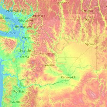
Name: Topografische Karte Washington, Höhe, Relief.
Ort: Washington, United States (45.54372 -124.83609 49.00244 -116.91599)
Durchschnittliche Höhe: 796 m
Minimale Höhe: -2 m
Maximale Höhe: 4.170 m
Washington is the 18th-largest state, with an area of 71,362 square miles (184,830 km2), and the 13th-most populous state, with more than 7.7 million people. The majority of Washington's residents live in the Seattle metropolitan area, the center of transportation, business, and industry on Puget Sound, an inlet of the Pacific Ocean consisting of numerous islands, deep fjords, and bays carved out by glaciers. The remainder of the state consists of deep temperate rainforests in the west; mountain ranges in the west, central, northeast, and far southeast; and a semi-arid basin region in the east, central, and south, given over to intensive agriculture. Washington is the second most populous state on the West Coast and in the Western United States, after California. Mount Rainier, an active stratovolcano, is the state's highest elevation at 14,411 feet (4,392 meters), and is the most topographically prominent mountain in the contiguous U.S.
Andere topografische Karten
Klicken Sie auf eine Karte, um ihre Topografie, ihre Höhe und ihr Relief anzuzeigen.
Los Angeles
Los Angeles, California, United States
Durchschnittliche Höhe: 241 m
Brooklyn
United States > New York > New York
Brooklyn, Kings County, New York, United States
Durchschnittliche Höhe: 9 m
Houston
United States > Texas > Harris County
Houston, Harris County, Texas, United States
Durchschnittliche Höhe: 25 m
Santa Cruz
United States > California > Santa Cruz County
Santa Cruz, Santa Cruz County, California, United States
Durchschnittliche Höhe: 89 m
Aurora
United States > Colorado > Adams County
Aurora, Adams County, Colorado, United States
Durchschnittliche Höhe: 1.691 m
Albuquerque
United States > New Mexico > Bernalillo County
Albuquerque, Bernalillo County, New Mexico, United States
Durchschnittliche Höhe: 1.688 m
Santa Barbara
United States > California > Santa Barbara County
Santa Barbara, Santa Barbara County, California, United States
Durchschnittliche Höhe: 119 m
Hillsborough County
Hillsborough County, Florida, United States
Durchschnittliche Höhe: 20 m
Parker
United States > Colorado > Douglas County
Parker, Douglas County, Colorado, 80134, United States
Durchschnittliche Höhe: 1.845 m
Jacksonville
United States > Florida > Duval County
Jacksonville, Duval County, Florida, United States
Durchschnittliche Höhe: 10 m
Whatcom County
Whatcom County, Washington, United States
Durchschnittliche Höhe: 753 m
Indianapolis
United States > Indiana > Indianapolis
Indianapolis, Marion County, Indiana, 46204, United States
Durchschnittliche Höhe: 241 m
Manhattan
United States > New York > New York County > New York
Manhattan, New York County, New York, United States
Durchschnittliche Höhe: 16 m
Arlington
United States > Massachusetts > Middlesex County
Arlington, Middlesex County, Massachusetts, United States
Durchschnittliche Höhe: 35 m
Lexington
United States > Kentucky > Lexington
Lexington, Fayette County, Kentucky, 40508, United States
Durchschnittliche Höhe: 285 m
Ridgefield
United States > Connecticut > Western Connecticut Planning Region
Ridgefield, Western Connecticut Planning Region, Connecticut, 06877, United States
Durchschnittliche Höhe: 183 m
Allegheny County
Allegheny County, Pennsylvania, United States
Durchschnittliche Höhe: 325 m
Cape Cod
United States > Massachusetts > Plymouth County
Cape Cod, Plymouth County, Massachusetts, United States
Durchschnittliche Höhe: 2 m