
Topografische Karte Montana
Interaktive Karte
Klicken Sie auf die Karte, um die Höhe anzuzeigen.
Über diese Karte
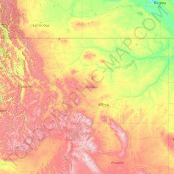
Name: Topografische Karte Montana, Höhe, Relief.
Ort: Montana, United States (44.35792 -116.04923 49.00111 -104.03956)
Durchschnittliche Höhe: 1.357 m
Minimale Höhe: 552 m
Maximale Höhe: 4.034 m
The state's topography is roughly defined by the Continental Divide, which splits much of the state into distinct eastern and western regions. Most of Montana's hundred or more named mountain ranges are in the state's western half, most of which is geologically and geographically part of the northern Rocky Mountains. The Absaroka and Beartooth ranges in the state's south-central part are technically part of the Central Rocky Mountains. The Rocky Mountain Front is a significant feature in the state's north-central portion, and isolated island ranges that interrupt the prairie landscape common in the central and eastern parts of the state. About 60 percent of the state is prairie, part of the northern Great Plains.
Andere topografische Karten
Klicken Sie auf eine Karte, um ihre Topografie, ihre Höhe und ihr Relief anzuzeigen.
Los Angeles
Los Angeles, Los Angeles County, California, United States
Durchschnittliche Höhe: 241 m
Houston
United States > Texas > Harris County
Houston, Harris County, Texas, United States
Durchschnittliche Höhe: 25 m
New Orleans
United States > Louisiana > Orleans Parish
New Orleans, Orleans Parish, Louisiana, United States
Durchschnittliche Höhe: 1 m
Brooklyn
United States > New York > New York
Brooklyn, Kings County, New York, United States
Durchschnittliche Höhe: 9 m
Jacksonville
United States > Florida > Duval County
Jacksonville, Duval County, Florida, United States
Durchschnittliche Höhe: 10 m
Fort Worth
United States > Texas > Tarrant County
Fort Worth, Tarrant County, Texas, United States
Durchschnittliche Höhe: 212 m
Honolulu
United States > Hawaii > Honolulu County
Honolulu, Honolulu County, Hawaii, United States
Durchschnittliche Höhe: 90 m
Boulder
United States > Colorado > Boulder County
Boulder, Boulder County, Colorado, United States
Durchschnittliche Höhe: 1.785 m
Fairfax County
Fairfax County, Virginia, United States
Durchschnittliche Höhe: 75 m
Montgomery County
Montgomery County, Texas, United States
Durchschnittliche Höhe: 69 m
Redondo Beach
United States > California > Los Angeles County
Redondo Beach, Los Angeles County, California, 90278, United States
Durchschnittliche Höhe: 19 m
Knoxville
United States > Tennessee > Knox County
Knoxville, Knox County, East Tennessee, Tennessee, United States
Durchschnittliche Höhe: 307 m
Corpus Christi
United States > Texas > Nueces County
Corpus Christi, Nueces County, Texas, United States
Durchschnittliche Höhe: 8 m
Santa Fe
United States > New Mexico > Santa Fe County
Santa Fe, Santa Fe County, New Mexico, United States
Durchschnittliche Höhe: 2.221 m
Saint Johns County
Saint Johns County, Florida, United States
Durchschnittliche Höhe: 6 m
Norfolk
United States > Virginia > Norfolk
Norfolk, Virginia, 23510, United States
Durchschnittliche Höhe: 4 m
Fresno
United States > California > Fresno County
Fresno, Fresno County, California, United States
Durchschnittliche Höhe: 98 m