
Topografische Karte Prudhoe Bay
Interaktive Karte
Klicken Sie auf die Karte, um die Höhe anzuzeigen.
Über diese Karte
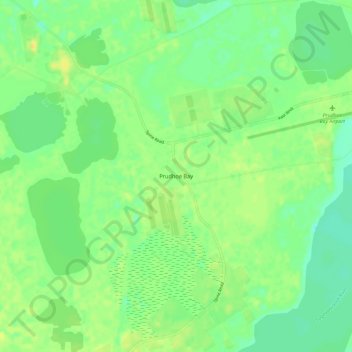
Name: Topografische Karte Prudhoe Bay, Höhe, Relief.
Ort: Prudhoe Bay, North Slope, Alaska, 99734, United States (70.22501 -148.41784 70.26501 -148.37784)
Durchschnittliche Höhe: 10 m
Minimale Höhe: 0 m
Maximale Höhe: 20 m
Andere topografische Karten
Klicken Sie auf eine Karte, um ihre Topografie, ihre Höhe und ihr Relief anzuzeigen.
Wainwright
United States > Alaska > North Slope
Wainwright, North Slope, Alaska, 99782, United States
Durchschnittliche Höhe: 5 m
Howe Island
United States > Alaska > North Slope
Howe Island, North Slope, Alaska, United States
Durchschnittliche Höhe: 0 m
Deadhorse
United States > Alaska > North Slope
Deadhorse, North Slope, Alaska, United States
Durchschnittliche Höhe: 15 m
Igloo Mountain
United States > Alaska > North Slope
Igloo Mountain, North Slope, Alaska, United States
Durchschnittliche Höhe: 592 m
Utqiaġvik
United States > Alaska > North Slope
Utqiaġvik, North Slope, Alaska, 99273, United States
Durchschnittliche Höhe: 4 m