
Topografische Karte Howe Island
Interaktive Karte
Klicken Sie auf die Karte, um die Höhe anzuzeigen.
Über diese Karte
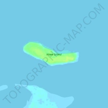
Name: Topografische Karte Howe Island, Höhe, Relief.
Ort: Howe Island, North Slope, Alaska, United States (70.31232 -148.00347 70.31825 -147.96204)
Durchschnittliche Höhe: 0 m
Minimale Höhe: -1 m
Maximale Höhe: 11 m
Andere topografische Karten
Klicken Sie auf eine Karte, um ihre Topografie, ihre Höhe und ihr Relief anzuzeigen.
Wainwright
United States > Alaska > North Slope
Wainwright, North Slope, Alaska, 99782, United States
Durchschnittliche Höhe: 5 m
Deadhorse
United States > Alaska > North Slope
Deadhorse, North Slope, Alaska, United States
Durchschnittliche Höhe: 15 m
Igloo Mountain
United States > Alaska > North Slope
Igloo Mountain, North Slope, Alaska, United States
Durchschnittliche Höhe: 592 m
Prudhoe Bay
United States > Alaska > North Slope
Prudhoe Bay, North Slope, Alaska, 99734, United States
Durchschnittliche Höhe: 10 m
Utqiaġvik
United States > Alaska > North Slope
Utqiaġvik, North Slope, Alaska, 99273, United States
Durchschnittliche Höhe: 4 m