
Topografische Karte Utqiaġvik
Interaktive Karte
Klicken Sie auf die Karte, um die Höhe anzuzeigen.
Über diese Karte
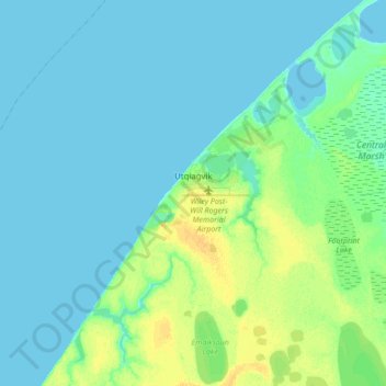
Name: Topografische Karte Utqiaġvik, Höhe, Relief.
Ort: Utqiaġvik, North Slope, Alaska, 99273, United States (71.23029 -156.92450 71.34026 -156.63934)
Durchschnittliche Höhe: 4 m
Minimale Höhe: 0 m
Maximale Höhe: 18 m
Despite the extreme northern location, temperatures at Utqiaġvik are moderated by the surrounding topography. The Arctic Ocean is on three sides, and flat tundra stretches some 200 miles (300 km) to the south. There are no wind barriers or protected valleys where dense cold air can settle or form temperature inversions in the lower atmosphere, as commonly happens in the interior between the Brooks and the Alaska ranges.
Andere topografische Karten
Klicken Sie auf eine Karte, um ihre Topografie, ihre Höhe und ihr Relief anzuzeigen.
Wainwright
United States > Alaska > North Slope
Wainwright, North Slope, Alaska, 99782, United States
Durchschnittliche Höhe: 5 m
Howe Island
United States > Alaska > North Slope
Howe Island, North Slope, Alaska, United States
Durchschnittliche Höhe: 0 m
Deadhorse
United States > Alaska > North Slope
Deadhorse, North Slope, Alaska, United States
Durchschnittliche Höhe: 15 m
Igloo Mountain
United States > Alaska > North Slope
Igloo Mountain, North Slope, Alaska, United States
Durchschnittliche Höhe: 592 m
Prudhoe Bay
United States > Alaska > North Slope
Prudhoe Bay, North Slope, Alaska, 99734, United States
Durchschnittliche Höhe: 10 m