
Topografische Karte Deadhorse
Interaktive Karte
Klicken Sie auf die Karte, um die Höhe anzuzeigen.
Über diese Karte
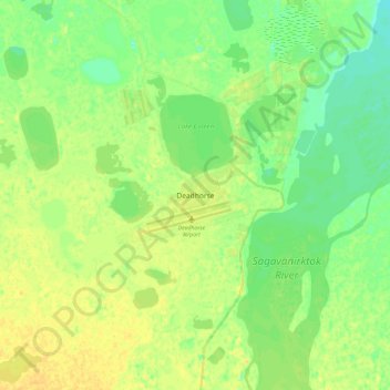
Name: Topografische Karte Deadhorse, Höhe, Relief.
Ort: Deadhorse, North Slope, Alaska, United States (70.03995 -148.62182 70.35995 -148.30182)
Durchschnittliche Höhe: 15 m
Minimale Höhe: -17 m
Maximale Höhe: 62 m
In February 2023, a "high altitude object" about the size of a small car was shot down near the area after a decision by President Joe Biden.
Andere topografische Karten
Klicken Sie auf eine Karte, um ihre Topografie, ihre Höhe und ihr Relief anzuzeigen.
Wainwright
United States > Alaska > North Slope
Wainwright, North Slope, Alaska, 99782, United States
Durchschnittliche Höhe: 5 m
Howe Island
United States > Alaska > North Slope
Howe Island, North Slope, Alaska, United States
Durchschnittliche Höhe: 0 m
Igloo Mountain
United States > Alaska > North Slope
Igloo Mountain, North Slope, Alaska, United States
Durchschnittliche Höhe: 592 m
Prudhoe Bay
United States > Alaska > North Slope
Prudhoe Bay, North Slope, Alaska, 99734, United States
Durchschnittliche Höhe: 10 m
Utqiaġvik
United States > Alaska > North Slope
Utqiaġvik, North Slope, Alaska, 99273, United States
Durchschnittliche Höhe: 4 m