
Topografische Karte Amhara Region
Interaktive Karte
Klicken Sie auf die Karte, um die Höhe anzuzeigen.
Über diese Karte
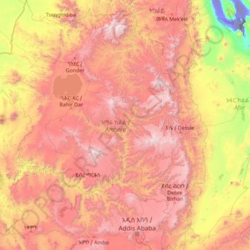
Name: Topografische Karte Amhara Region, Höhe, Relief.
Ort: Amhara Region, Ethiopia (8.71589 35.26165 13.78090 40.21334)
Durchschnittliche Höhe: 1.618 m
Minimale Höhe: -114 m
Maximale Höhe: 4.454 m
The Amhara region has the most world heritage sites of any region in Ethiopia and is endowed with natural and geographic wonders and ecosystems. The region contains Ethiopia's largest inland body of water Lake Tana, which is the source of the Blue Nile river. In 2015 Lake Tana was recognized as a UNESCO Biosphere Reserve for its enormous biodiversity, and national and international importance. The Semien Mountains National Park has been designated as one of the first natural World Heritage Site by UNESCO in the world, and the very first in Africa in the natural criteria since 1978. Chosen for its spectacular landscapes and global significance for biodiversity conservation. Situated within the Semien Mountains, Ethiopia's highest peaks Ras Dashen reaches an elevation of (4,543 m (14,905 ft)). The park also has Ethiopia's second and third highest mountains, Kidis Yared (4,453 m (14,610 ft)) and Mount Bwahit (4,437 m (14,557 ft)). The park is home to endangered species found nowhere else in the world, examples of endemic fauna include the iconic walia ibex, the gelada baboon, and the Ethiopian wolf (or Simien fox) among others. The wide range of altitudes has given the country a variety of ecologically distinct areas, leading to the evolution of endemic species in ecological isolation.
Andere topografische Karten
Klicken Sie auf eine Karte, um ihre Topografie, ihre Höhe und ihr Relief anzuzeigen.
Belta
Ethiopia > Southern Nations, Nationalities, and Peoples
Belta, Gamo Gofa, Southern Nations, Nationalities, and Peoples, Ethiopia
Durchschnittliche Höhe: 2.613 m
Butajira
Ethiopia > Southern Nations, Nationalities, and Peoples
Butajira, Guraghe, Southern Nations, Nationalities, and Peoples, Ethiopia
Durchschnittliche Höhe: 2.078 m
Dera
Dera, East Shewa, Oromia Region, Ethiopia
Durchschnittliche Höhe: 1.349 m
Burayu
Ethiopia > Oromia Region > Walmara
Burayu, Walmara, West Shewa, Oromia Region, Ethiopia
Durchschnittliche Höhe: 2.574 m
Bahir Dar Special Zone
Bahir Dar Special Zone, Amhara Region, Ethiopia
Durchschnittliche Höhe: 1.794 m
Manu
Manu, North Gondar, Amhara Region, Ethiopia
Durchschnittliche Höhe: 1.057 m
Shola Park
Ethiopia > Addis Ababa > Yeka
Shola Park, Yeka, Addis Ababa, Ethiopia
Durchschnittliche Höhe: 2.440 m
Wag
Wag, Wag Hemra Zone, Amhara Region, Ethiopia
Durchschnittliche Höhe: 2.024 m
Dalol Bota
Dalol Bota, Zone 2, Afar Region, Ethiopia
Durchschnittliche Höhe: 57 m
Adi Arkay
Adi Arkay, North Gondar, Amhara Region, Ethiopia
Durchschnittliche Höhe: 1.439 m
Great Rift Valley
Great Rift Valley, Borena, Oromia Region, Ethiopia
Durchschnittliche Höhe: 631 m
Yangudi Rassa National Park
Yangudi Rassa National Park, Afar Region, Ethiopia
Durchschnittliche Höhe: 622 m
Jijiga
Ethiopia > Somali Region > Jijiga
Jijiga, Somali Region, Ethiopia
Durchschnittliche Höhe: 1.732 m
Adama
Ethiopia > Oromia Region > Adama
Adama, East Shewa, Oromia Region, 36, Ethiopia
Durchschnittliche Höhe: 1.673 m
Nech Sar National Park
Ethiopia > Southern Nations, Nationalities, and Peoples > Arba Minch
Nech Sar National Park, Arba Minch, Gamo Gofa, Southern Nations, Nationalities, and Peoples, Ethiopia
Durchschnittliche Höhe: 1.215 m
Danakil Depression
Danakil Depression, Zone 2, Afar Region, Ethiopia
Durchschnittliche Höhe: -105 m
Arba Minch
Ethiopia > Southern Nations > Arba Minch
Arba Minch, Gamo Gofa, Southern Nations, 40, Ethiopia
Durchschnittliche Höhe: 1.455 m
Kore
Ethiopia > Southern Nations, Nationalities, and Peoples > Nili
Kore, Nili, South Omo, Southern Nations, Nationalities, and Peoples, Ethiopia
Durchschnittliche Höhe: 544 m
Wegel Tena
Wegel Tena, North Wollo, Amhara Region, Ethiopia
Durchschnittliche Höhe: 2.936 m
Gashena Maryam Bete Kristiyan
Gashena Maryam Bete Kristiyan, North Wollo, Amhara Region, Ethiopia
Durchschnittliche Höhe: 2.436 m
Sodo
Ethiopia > Southern Nations > Sodo
Sodo, Wolayita, Southern Nations, Ethiopia
Durchschnittliche Höhe: 1.873 m
Shire Enda Silassie
Ethiopia > Tigray > Shire Enda Silassie
Shire Enda Silassie, Western Tigray, Tigray, Ethiopia
Durchschnittliche Höhe: 1.912 m
Debre Markos
Debre Markos, East Gojjam, Amhara Region, Ethiopia
Durchschnittliche Höhe: 2.343 m
Gode
Ethiopia > Somali Region > Gode
Gode, Unknown, Somali Region, Ethiopia
Durchschnittliche Höhe: 295 m
Asaita
Ethiopia > Afar Region > Asaita
Asaita, Zone 1, Afar Region, Ethiopia
Durchschnittliche Höhe: 366 m
Seka
Ethiopia > Oromia Region > Seka
Seka, Jimma, Oromia Region, Ethiopia
Durchschnittliche Höhe: 1.827 m
Bitata
Ethiopia > Oromia Region > Bitata
Bitata, Borena, Oromia Region, Ethiopia
Durchschnittliche Höhe: 1.483 m
Nekemte
Ethiopia > Oromia Region > Nekemte
Nekemte, Oromia Region, Ethiopia
Durchschnittliche Höhe: 1.910 m
Ahmar Mountains
Ahmar Mountains, West Harerghe, Oromia Region, Ethiopia
Durchschnittliche Höhe: 1.777 m